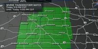
Severe weather warnings are in effect across North Texas as a complex of thunderstorms moves through the region, bringing heavy rain, hail, and potential tornadoes. On Wednesday, April 23, 2025, a severe thunderstorm watch was issued for Collin, Denton, Grayson, and Cooke counties until 7 a.m., while a flash flood warning was in effect for portions of Dallas, Tarrant, and Ellis counties until 9:15 a.m.
Early in the morning, around 5:30 a.m., a ground stop was implemented at Dallas-Fort Worth International Airport due to the storms. Reports indicated that heavy rain and hail, with some stones reaching the size of eggs, fell in western areas of the Dallas-Fort Worth Metroplex. Meteorologists from CBS News Texas have designated both Wednesday and Thursday as First Alert Weather Days, anticipating a disruptive and rainy pattern.
As the day progresses, temperatures in North Texas are expected to peak at 79 degrees. The storms are not expected to dissipate quickly; rather, they will continue to develop throughout the day and into the night. "The heavy rain will continue off and on into the afternoon hours with more storms developing overnight into Thursday," a meteorologist stated.
Looking ahead, there is a chance of additional showers and storms as early as Friday morning, particularly near the Red River, due to a disturbance moving through southern Oklahoma. Meteorologists noted some uncertainty regarding how widespread this activity will be, but they warned that the atmosphere's instability could lead to strong or even marginally severe storms.
In a related weather update, the National Weather Service (NWS) reported that a tornado warning was issued for Motley County until 9:30 p.m. on Tuesday, April 22, 2025. The warning was prompted by significant rotation detected on radar, although it was allowed to expire as the rotation weakened. However, severe thunderstorm warnings remain in effect for Floyd and Motley counties due to the potential for hail and damaging winds.
As of 10:41 p.m. on Tuesday, the NWS had lifted the severe watch for Lubbock and the central South Plains, but a watch remains for the Rolling Plains east of Lubbock until 1 a.m. Wednesday. The storms that developed earlier in the evening were slow-moving, leading to localized flooding, with the potential for one to three inches of rain already fallen and another inch or two expected.
On Wednesday morning, the NWS Fort Worth TX released an updated severe thunderstorm warning for Collin County at 5:48 a.m., effective until 6:30 a.m. The storm was reported to be packing quarter-sized hail and wind gusts up to 60 mph. "At 5:48 a.m., a severe thunderstorm was located near Frisco, moving east at 30 mph," the NWS stated. The storm is expected to cause damage to vehicles and pose risks to roofs, siding, and trees.
Locations that may be affected by this severe thunderstorm include McKinney, Frisco, and Prosper, with warnings extending to Melissa and other nearby communities.
In light of these severe weather conditions, the NWS advises residents to stay indoors and away from windows for safety. The NWS also provided safety tips for those caught in thunderstorms, emphasizing the importance of seeking shelter and avoiding contact with corded phones, electrical equipment, and plumbing.
Driving during these severe weather conditions poses additional risks. The NWS recommends turning on headlights to improve visibility, avoiding puddles that can cause hydroplaning, and steering clear of flooded areas. "Flash flooding currents are strong and can sweep drivers off roadways," the NWS cautioned.
As the week progresses, North Texas will remain in a warm and moist environment, which keeps thunderstorm chances in the forecast. Most of the region is expected to experience dry weather from Sunday into Monday, but storm chances will increase again later on Monday. A cold front is predicted to sweep through on Wednesday, April 30, potentially bringing another round of rain and slightly cooler temperatures.
With an active weather pattern anticipated, residents are urged to stay informed and prepared for changing conditions. Meteorologists continue to monitor the situation closely, and updates will be provided as necessary.