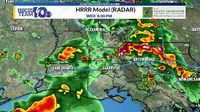
The National Weather Service in Wichita has issued a severe thunderstorm warning for northeastern McPherson County and southeastern Saline County, effective until 10:45 p.m. on April 22, 2025. As of 10:05 p.m., a severe storm was located approximately 7 miles south of Gypsum, or 12 miles east of Lindsborg, moving east at 15 mph. The storm poses serious hazards, including hail up to 2 inches in diameter and wind gusts reaching 60 mph.
Residents in the affected areas, including Gypsum and Roxbury, are advised to seek shelter in an interior room on the lowest floor of a sturdy building. The storm's potential for significant damage cannot be overstated, with large hail capable of damaging roofs, windows, siding, and vehicles, while strong winds could wreak havoc on trees and structures.
In addition to the severe weather in Kansas, Louisiana is experiencing its share of storm activity. Reports indicate that some nickel-sized hail was likely occurring between Carencro and Sunset on the same day. A strong storm was also observed across northern St. Landry and southeastern Avoyelles Parish, prompting a severe thunderstorm warning due to the threat of strong winds and small hail.
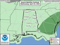
As the storm system moves slowly east, it is expected to bring heavier rainfall to the region. The Storm Prediction Center has classified the area under a level one risk of severe storms, suggesting that residents should remain vigilant.
Scattered storms have been a common sight throughout the day, as a frontal boundary remains stalled in the moisture-rich atmosphere. The storms are characterized by gusty winds, frequent lightning, and heavy rainfall, with the potential for flash flooding if a storm stalls over a location.
Looking ahead, the forecast indicates that storms could linger into the late evening, particularly for northern areas of Acadiana and central parts of the state. April 23, 2025, is expected to bring another day of widespread storms, with rain coverage predicted to be around 70%. The storms are projected to continue through April 24, 2025, before a ridge of high pressure begins to build from the south.
This high pressure will result in a decrease in atmospheric moisture and lift, pushing the main frontal boundary northward. Consequently, the rain chances are expected to diminish as the week progresses, with isolated storm chances (20%) anticipated for both April 26 and 27, 2025.
As the storm activity subsides, temperatures are expected to rise significantly, with highs climbing into the upper 80s on the weekend of April 26 and 27. This shift towards drier and hotter weather patterns is likely to continue into early next week, providing a stark contrast to the stormy conditions experienced earlier in the week.
Residents in both Kansas and Louisiana are urged to stay informed about the weather conditions and heed warnings from the National Weather Service as the severe weather unfolds. It is crucial to remain prepared and take necessary precautions to ensure safety during these turbulent weather events.