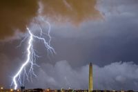
On July 1, 2025, residents of the Mid-Atlantic and Northeast regions faced a day of intense and potentially dangerous weather as clusters of severe storms developed ahead of a slow-moving cold front. The storms, which began forming in the afternoon, were expected to heavily impact the evening commute along the Interstate 95 corridor, stretching from New York City through Philadelphia, Baltimore, and down to Washington, D.C.
The National Weather Service (NWS) had issued multiple warnings, including severe thunderstorm watches and flood watches, signaling the seriousness of the situation. These alerts remained in effect through the evening, with flood watches extending until 11 p.m. in many areas. The NWS forecast map highlighted a moderate risk zone—indicating at least a 40 percent chance of excessive rainfall—covering northern Virginia, far eastern West Virginia, Maryland, northern Delaware, southern Pennsylvania, and Washington, D.C.
Washington, D.C., in particular, was bracing for up to three inches of rain, with the possibility of even higher amounts. NWS meteorologist Kevin Witt told Newsweek, "We've been getting a lot of rain lately, so flooding is definitely a possibility." The heavy rainfall, combined with recent wet conditions, raised concerns for flash flooding, especially in urban areas where drainage systems can be quickly overwhelmed.
As the day progressed, the D.C. region experienced a powerful wave of severe thunderstorms that hit just before 3 p.m. Wind gusts were notably strong, with speeds reaching 49 mph recorded at the Bay Bridge around 4:34 p.m. These winds, coupled with intense rainfall, led to multiple reports of damage. Around 3:30 p.m., authorities received calls about large tree limbs blocking roads in southern Arlington and a tree that had fallen onto a car on Old Frederick Road in Sykesville.
Weather experts warned that the storms could also produce hail and damaging wind gusts. Eileen Whelan, a meteorologist with 7News First Alert, cautioned that "storms could contain damaging wind gusts and hail," while pockets of heavy rain were already causing standing water on roads, urging drivers to exercise caution during the afternoon and evening hours.
The severe weather was driven by a strong cold front moving across the region, which not only whipped up the thunderstorms but also promised some relief in the coming days by bringing a drop in humidity. Temperatures on July 1 soared near 90 degrees Fahrenheit, with heat index values making it feel like 100 degrees, creating a hot and muggy atmosphere before the storms hit.
The Federal Aviation Administration (FAA) responded to the severe weather by implementing ground stops at major airports. Dulles International and BWI Marshall airports maintained ground stops until 9:15 p.m., while an earlier hold at Reagan National Airport was lifted. These measures underscored the widespread disruption caused by the storms, affecting both ground transportation and air travel.
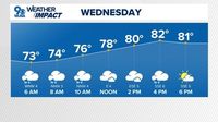
Despite the challenging weather on July 1, forecasts for the following days brought some relief. Storms were expected to taper off overnight into scattered showers on July 2, with highs holding in the 80s and humidity levels dropping. The cold front was anticipated to push through by midday on July 2, ushering in drier air and clearer skies for the afternoon.
Looking ahead to the Fourth of July holiday, meteorologists projected very favorable weather conditions. The holiday weekend was forecast to be mostly sunny with comfortable highs in the mid-80s and low humidity, a welcome change after the severe storms and oppressive heat. "Fourth of July weather looks great," said Whelan, highlighting the expected low humidity and pleasant temperatures ideal for outdoor celebrations and events, including concerts and fireworks displays.
The NWS emphasized that while the severe weather on July 1 was significant, such storms are not uncommon for this time of year, as July remains within D.C.'s severe weather season. Multiple rounds of thunderstorms were possible throughout the day, with heavy instantaneous rainfall rates and potential training of storms—where storms repeatedly pass over the same area—heightening the risk of flash flooding.
Authorities and weather experts urged residents to stay alert and heed warnings as the system moved through. The flood watches and severe thunderstorm watches served as critical reminders of the potential hazards, including damaging winds, heavy rain, and flash flooding.
By the evening of July 1, the flood watches were still in effect, but the outlook beyond that was more optimistic. No hazardous weather was expected from July 2 through July 5, allowing residents to enjoy a safer and more comfortable start to the holiday weekend.
Overall, the severe weather event on July 1, 2025, served as a stark reminder of the power of nature during the summer months in the Mid-Atlantic region. With careful preparation and timely warnings, officials aimed to minimize damage and keep communities safe as they navigated through the storms and looked forward to clearer skies ahead.