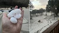
SAN ANTONIO — Strong storms recently swept across the San Antonio region, bringing with them large hail, severe wind gusts, and crucial rainfall. On the evening of March 23, 2025, Kerrville was hit by intense weather, as residents reported golf ball-sized hail or larger, causing significant alarm.
A Severe Thunderstorm Warning was in effect for parts of Gonzales and Guadalupe counties until midnight, as storms raged across the area. As of 11:30 p.m., CPS Energy noted that fewer than 400 customers were affected by power outages, managing to keep the disruptions to a minimum during these turbulence-filled hours. Meanwhile, multiple counties remained under a Severe Thunderstorm Watch until 1 a.m. on March 24, 2025. This included Bastrop, Blanco, Burnet, Caldwell, Comal, Gillespie, Guadalupe, Hays, Kendall, Lee, Llano, Travis, and Williamson.
The National Weather Service (NWS) extended the Severe Thunderstorm Watch to include Bandera, Kerr, and Bexar County, heightening concerns as wind speeds were expected to reach between 50 and 60 mph in the greater San Antonio area. Residents braced for the potential of significant hail and high winds, although flooding was not a major concern at the time, given that the thunderstorms were anticipated to pass quickly across the heavily trafficked Interstate 35 corridor.
The Hill Country experienced especially harsh conditions on that Sunday evening, with many individuals taking to KSAT Connect to share dramatic photos and videos of the hail barrage that struck their neighborhoods. Reports of heavy rainfall were widespread, maintaining a consistent theme of severity and urgency among the meteorological updates.
KSAT meteorologists had anticipated the arrival of thunderstorms coinciding with a cold front that evening. They highlighted that this active weather pattern was expected to be indicative of a larger trend, as more moisture was set to arrive later in the week. "Whatever the weather, it's been a rollercoaster not only for San Antonio but for most of the state of Texas," reported KSAT, reflecting on the turbulent weather changes recently experienced in the region.
Looking forward, the NWS indicated that the most active week of weather so far this spring was on the horizon. They anticipated that strong storms would roll in through the evening and early morning, particularly hitting areas along and north of a line stretching from Burnet to San Marcos and La Grange. "Large hail and damaging winds are the main severe weather concerns," the NWS added, further driving home the need for preparation among impacted residents.
As the week progressed, the temperatures were initially warm, reaching around 85 degrees throughout many parts of South Central Texas, but the nights would cool substantially, dropping nearly 20 degrees. Showers and thunderstorms were expected to arrive between 10 p.m. on March 23 and 1 a.m. on March 24.
When Monday, March 24, arrived, forecasters predicted that conditions would remain warm, with some highs potentially climbing into the lower 90s. The following days, specifically March 26 to March 28, were forecasted to see rain chances making a comeback. Wednesday called for a 20-30% chance of rain, while Thursday was highlighted with an 80% chance, offering what could be significant rainfall after a dry spell.
Overall, the weather outlook for Texas appeared volatile, with constant changes likely due to the active spring weather pattern. Meteorologists reminded residents to keep jackets and umbrellas handy as they braced for what could be a chaotic week ahead. The unpredictability kept people on their toes, uncertain and waiting for the next weather challenge to arrive.
In summary, as storms continued to impact several counties, the people of San Antonio and surrounding areas remained alert and prepared for ongoing unpredictable weather conditions.