CEDAR RAPIDS, Iowa (Iowa's News Now) — A strong storm rolled through Cedar Rapids on Wednesday morning, causing hail to cover the streets and prompting weather alerts across the region. A Severe Thunderstorm Warning was issued for Linn County at 5:30 a.m. on March 19, 2025, due to reports of quarter-size hail. Although the hail did not reach the size initially predicted, it fell rapidly, resulting in streets near Aplington being coated in white.
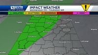
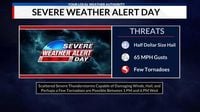
The rapid development of storms is a shared concern across the Midwest this Wednesday, contributing to an overall Severe Weather Alert Day across several states. In Peoria, Illinois, a severe weather alert was also activated, where the local weather authority predicted severe storms in the afternoon. Experts highlighted the potential for wind gusts reaching up to 65 mph, half-dollar-sized hail, and even a few tornadoes.
The National Weather Service (NWS) has placed much of Central Illinois under a Level 3 Risk (Enhanced Risk) for severe weather this afternoon. The storm system is expected to unleash a broken band of thunderstorms along a cold front, moving northeast at about 30 mph. These powerful storms are projected to begin between 1 p.m. and 6 p.m., with residents being urged to stay prepared for severe hazards, including damaging winds and possible tornadoes.
In addition to Iowa and Illinois, Louisville, Kentucky, is bracing for significant storms later in the day. The NWS issued a wind advisory effective from 11 a.m. to 11 p.m., anticipating strong winds exceeding 40 mph and a potential for severe storms starting between 6 p.m. and 8 p.m.
The advisory highlights that while the weather in Louisville carries a marginal risk for severe conditions, the presence of strong winds and possible hail will pose complications for many households and motorists. Meanwhile, Louisville is set to see a warm day with temperatures nearing 71 degrees before conditions shift dramatically to colder patterns.
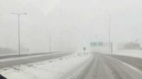
As the storm systems progressed west towards Nebraska, blizzard conditions began to affect travel. Eastern Nebraska faced heavy snow and strong winds that contributed to low visibility. After a thunderstorm moved through Omaha earlier that morning, hail coated the roads, leading the Nebraska Department of Transportation to close I-80 in both directions from Lexington to Lincoln due to unsafe conditions. The storm’s trajectory resulted in changing weather patterns, with rain turning into sleet and snow, making for hazardous driving situations across the state.
In a more extensive view of the region's weather impact, heavy snowfall and transitioning systems have not only affected visibility but also created precarious road conditions. KETV reporter Anna Behning described challenges faced around Fremont, noting that rain began to transition to sleet already by 5 a.m. This swift change in conditions can be attributed to the unstable atmosphere and the potential for a significant weather event lingering into the nighttime hours.
Later Wednesday night, areas from Alabama onward are also expecting to experience the brunt of the storms as a cold front will bring rain before transitioning to snow late into the evening. In Alabama, the storms arriving after dark will affect residents until Thursday morning, generating winds of 30-40 mph.
The Storm Prediction Center identified a marginal risk on March 19 in northwestern Alabama, a part of which was impacted recently by a series of tornadoes that left three people dead in a separate weather event over the weekend. The aftermath of that tornado outbreak still follows with crews surveying regions of damage as they ascertain the specifics of storm impact.
As severe storm patterns develop into Wednesday evening, forecasters will continue to monitor the situation with updated alerts and weather warnings being broadcast regularly. Preparedness for these rapidly changing weather conditions is advised, as storms produce various hazards for communities.
In conclusion, as the severe weather sweeps across multiple states including Iowa, Illinois, Kentucky, Nebraska, and Alabama, residents are encouraged to remain alert, prepare for severe conditions, and follow local updates closely. This underlines the unpredictable nature of spring storms, which can change rapidly and with little notice, emphasizing the importance of staying informed.