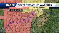
Severe storms swept through the Louisville area and southern Indiana Wednesday night, prompting significant weather alerts for local residents. A tornado watch was issued for much of the WLKY viewing area until midnight EDT, alongside a severe thunderstorm watch for the far north and northeastern communities until 1 a.m. EDT on Thursday, March 20, 2025.
As the storms approached from the west, meteorologists noted the potential for powerful weather conditions across the region. According to the WLKY weather team, the tornado watch encompasses the Louisville metro area, where residents were advised to stay alert. The storms were expected to peak between 7 p.m. and midnight on Wednesday.
The risk levels assigned to different areas also varied, with northwestern communities classified under the 'slight' risk, which ranks as level 2 out of 5, indicating a more significant threat, while the Louisville area was under a 'marginal' risk category, the lowest designation. These classifications serve as critical indicators of the severity and probability of storm activity in the affected areas.
According to forecasters, strong and potentially damaging winds would accompany the storms, with gusts reaching up to 70 miles per hour expected in some locations. Additionally, there was a chance for brief spin-up tornadoes to develop among the line of storms traversing the area, significantly increasing the urgency of these alerts.
The timeline for storm activity indicated that severe weather was most likely to impact communities as the evening progressed into the late hours. This led to heightened concerns among meteorologists, who urged vigilance from residents. "Strong, damaging winds and perhaps a brief spin-up tornado may develop along the line of storms," the team warned.
As the storm system moved across the Ohio Valley, heavy rain and the potential for hail were significant considerations, with forecasters noting that localized flooding could also occur as the storms delivered intense downpours.
Amid these warnings, Eric Zuanich from the WLKY weather team highlighted the presence of a prominent storm that was displaying signs of rotation, though officials clarified that it had not yet crossed the critical threshold into confirmed tornado activity. Still, the dynamism of the storm prompted advisories for impacted counties such as Jennings County and Jefferson County, which saw storm cells moving through quickly.
By late evening, the weather patterns indicated a gradual weakening of severe conditions, although heavy rains and gusty winds remained a threat in certain areas.
Looking ahead, the impending arrival of colder air was also a topic of conversation among meteorologists. As the storms dissipated, temperatures were expected to plummet into the 40s for the first day of Spring, bringing along with it a likelihood of drizzle or flurries as a final twist to the latest weather front.
Clearly, the severe storms and subsequent weather watch served as a reminder of the unpredictable nature of springtime weather in the region. With forecasts in place, authorities underscored the importance of staying up-to-date with alerts and safety information.
Residents were encouraged to educate themselves on safety protocols should the storms develop beyond their current state. This includes having emergency plans and supplies readily available, particularly in areas under severe weather warnings. Reminders about the often-volatile spring weather serve as crucial preparations for those living in Louisville and southern Indiana.
The interplay of severe storms, official warnings, and rapidly changing temperatures illustrates the dynamic weather patterns typical for this time of year. As local residents braced themselves for the storms’ impact, the hope was for minimal disruptions and a safe transition into the new season.
In summary, the evening of March 19 brought a potent mix of severe weather to the Louisville area, with tornado watches and storm threats forcing residents to remain alert and cautious as conditions evolved swiftly. As the storms passed, the forecast of colder temperatures and the possibility of lingering precipitation underscored the continued need for vigilance.