On Saturday, April 19, 2025, severe storms wreaked havoc across the Concho Valley, bringing with them tornado activity and hail that raised concerns among residents. The National Weather Service (NWS) confirmed a tornado was on the ground near the Tom Green and Sterling county line, prompting immediate warnings for those living in the affected areas.
According to KLST-TV Meteorologist Reagan Burke, there was significant rotational activity reported in Sterling County. Trained storm spotters observed a tornado along with hail measuring two inches in diameter, which is substantial enough to cause damage. The Sterling County Sheriff’s Office took to social media to alert the community, stating that the tornado was sighted about 12 miles south of Sterling City and was moving towards Broome around 4 p.m.
As the situation evolved, the NWS reported that rotations intensified again around 4:50 p.m. near Water Valley, leading officials to urge residents from Water Valley into northern Coke County to take cover immediately. This was not an isolated incident, as other areas, including Tom Green County, Robert Lee, and Sterling City, were under severe thunderstorm warnings, with the NWS predicting the possibility of hail larger than baseballs.
Earlier in the day, at approximately 3:30 p.m., a severe thunderstorm warning was issued for portions of Irion County, Sterling County, and the panhandle of Tom Green County. The storm was initially producing tennis ball-sized hail as it progressed into the western Concho Valley. An updated alert sent out at 4:40 p.m. reiterated the severe thunderstorm warning for Tom Green County, specifically mentioning the towns of Robert Lee and Sterling City.
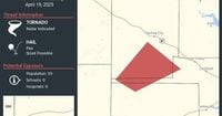
Despite the tornado being confirmed, the area affected is largely unpopulated, with fewer than 60 residents living in the immediate danger zone, about 35 miles northwest of San Angelo. Nevertheless, safety measures were prioritized, and residents were advised to stay indoors and away from windows as the storm moved eastward.
As the storm continued to develop, it became evident that the severe weather posed a significant threat to the region. The NWS emphasized the importance of taking cover, especially for those in extreme northern Tom Green County and southern Coke County. The warnings served as a critical reminder of the unpredictable nature of severe weather in Texas, where conditions can change rapidly.
The situation remained fluid throughout the day, with meteorologists continuing to monitor the storm's path and intensity. As evening approached, the community remained on high alert, with local authorities and emergency services prepared to respond to any incidents that might arise from the severe weather.
This incident highlights the importance of staying informed during severe weather events. With the advancements in meteorological technology and the dedication of local storm spotters, residents were able to receive timely warnings that could potentially save lives.
As of the latest updates, the storm was expected to continue moving through the Concho Valley, prompting ongoing vigilance from both residents and local officials. The NWS urged everyone to heed warnings and stay tuned for further updates regarding the storm's progression.
The events of April 19 serve as a stark reminder of the power of nature and the critical need for preparedness in the face of severe weather. As communities across Texas brace for potential storms in the future, the lessons learned from this incident will undoubtedly shape how residents respond to similar threats.