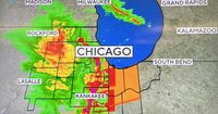
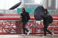
A line of severe storms triggered a tornado warning in Will County and a tornado watch for a large swath of the southwest suburbs and northwest Indiana on March 19, 2025, bringing dangerous winds, hail, and blinding downpours. A Severe Thunderstorm Warning was in effect for Jasper, Lake, Newton, and Porter counties in Indiana until 6:45 p.m., with another warning for La Porte County until 7 p.m. According to Doppler radar, conditions favorable for a tornado were detected near Kankakee, with rotation noted in a storm near the area. Residents were urged to prepare for intense rainfall, gusting winds, and hail.
Additionally, a Tornado Watch was in place for Kankakee, Ford, and Livingston counties in Illinois as well as Benton and Newton counties in Indiana until 9 p.m. Meanwhile, Will County was previously included in the watch but had it canceled by the 6 p.m. hour. Disruptions followed the severe storms, as a ground stop was initiated at Chicago O'Hare and Midway international airports due to the severe weather, which lifted shortly after 5:45 p.m. Travelers were advised to expect delays at these major airports.
Reports emerged of local damage from the severe weather, including downed trees in West Chicago and a semi-trailer truck flipped in south suburban New Lenox. The West Chicago Police Department confirmed that all lanes of Prince Crossing Road were shut down between North Avenue and Hawthorne Lane as utility poles and wires were down, blocking the road. Chicago's Office of Emergency Management and Communications also issued a warning about hail storms affecting the South Side earlier in the afternoon. Warning sirens were activated in Kankakee, prompting CBS News Chicago's Weather Lab crew to seek shelter as hail storms were reported in Oak Lawn and Lemont.
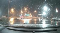
As the evening progressed, forecasts indicated that snow would follow the severe weather. Meteorologists anticipated a rain/snow mix moving into the Chicago area beginning around 11 p.m. The western suburbs could see between one to three inches of snow accumulation overnight into March 20, particularly as the temperatures dropped. The National Weather Service (NWS) issued a Wind Advisory for Boone, Cook, DeKalb, DuPage, Will, Kane, Kendall, Lake, McHenry, and Winnebago counties in Illinois as well as Lake and Porter counties in Indiana starting at 10 p.m. and lasting until 7 a.m. March 20. Travelers could expect hazardous winter conditions into the morning rush hour.
To help residents navigate the unpredictable weather, a quick primer on weather alerts was provided. A watch signifies that severe weather is possible, while a warning indicates that severe weather is imminent or already occurring. Following the guidance during a tornado warning is crucial: individuals should seek shelter immediately in a basement, storm shelter, or interior room without windows. Keeping supplies such as water, a flashlight, and communication devices handy is advised as well.
The full forecast for the Chicago area anticipated a chaotic morning on March 20 due to a mix of rain and snow. Minor accumulations between half an inch and two inches were expected, particularly impacting early commuters. However, the weather was predicted to become more seasonal by Friday and Saturday, with temperatures returning to near 60 degrees.
As the day unfolded on March 19, the system continued to demonstrate the volatile nature of spring weather in the Midwest. Strong winds followed the storms, with gusts recorded at remarkable speeds. A gust of 67 miles per hour was noted in Batavia, while other areas experienced winds peaking at 71 miles per hour in Park Forest. The storms prompted multiple alerts across Kankakee County and beyond.
The conditions served as a stark reminder of how quickly spring weather can evolve, illustrating the importance of preparedness during this tumultuous season. With meteorologists warning potential tornadoes and having residents remain vigilant, the community was left grappling with chaotic conditions in their efforts to remain safe amidst the weather turmoil. The National Weather Service continued to monitor the situation, providing updates and advisories to keep residents informed.
Looking ahead, as temperatures began to stabilize, they were forecasted to fluctuate between the 30s and 40s through the weekend, with additional chances of rain showers expected Sunday night into Monday. The significant swings in temperatures underscore the need for the public to stay informed and prepared as the weather continues its capricious dance throughout this early spring.