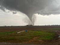
Severe storms swept through the U.S. South and Midwest on April 2, 2025, unleashing damaging tornadoes and causing widespread flooding across several states. The National Weather Service (NWS) warned of a "barrage of life-threatening weather hazards" as the powerful spring storm system moved through the region, affecting areas from Arkansas to Indiana.
As the storms rolled in, at least 11 tornado reports were confirmed, with nine of them occurring in Missouri and two in Arkansas. The NWS issued nearly two dozen tornado warnings, including a tornado emergency in Lake City, Arkansas, where residents were urged to take cover as a large tornado was on the ground.
In western Kentucky, four people sustained injuries due to a tornado, highlighting the storm's destructive impact. The NWS reported that the storm system was expected to bring a "multi-day catastrophic and potentially historic heavy rainfall event," raising concerns about flash flooding in the affected areas.
Arkansas Governor Sarah Huckabee Sanders declared a state of emergency ahead of the storms, stating, "We have reports of storm and tornado damage from around the state." This declaration aimed to mobilize resources to assist with recovery efforts in the wake of the severe weather.
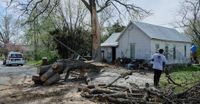
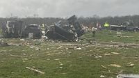
In Vernon County, Missouri, an EF-1 tornado struck on Wednesday morning, knocking over eight train carriages and causing damage to several homes and businesses. The tornado also uprooted numerous trees, demonstrating the storm's ferocity. Damage was reported in the Potosi area of Washington County, Missouri, and near Brownsburg, Indiana, where a tornado warning was also in effect.
Rainfall totals are expected to reach alarming levels, with predictions of over 15 inches in some regions, particularly in northeastern Arkansas, northwestern Tennessee, and western Kentucky. The NWS warned of "generational flooding" in these areas, describing the situation as a rare, high-impact, and potentially devastating event.
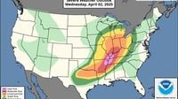
As the storm system continued to evolve, the Storm Prediction Center issued a "high risk" warning for severe weather in the mid-Mississippi Valley to the Lower Ohio Valley. This warning indicated the likelihood of numerous tornadoes, including long-track EF-3+ tornadoes, which can produce wind gusts between 136 and 165 miles per hour.
In addition to tornadoes, the storm brought intense thunderstorms, damaging winds, and large hail. The National Weather Service cautioned that conditions were ripe for severe weather across a vast area stretching from Texas to Minnesota and Maine.
As of early Thursday, April 3, tornado watches were in effect for more than a half-dozen states in the Mid-South, with residents advised to remain vigilant. The severe weather threat was expected to persist, with forecasters warning that the storm system could lead to further tornadoes and torrential rain over the coming days.
In Indiana, emergency responders were dispatched to assist individuals trapped in storm-damaged buildings. Reports indicated that a warehouse had partially collapsed in Hendricks County, and numerous power lines and trees were down due to the storms.
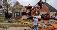
In Monette, Arkansas, multiple houses were damaged, and emergency responders helped two individuals trapped in a residence. Fortunately, as of Wednesday evening, there were no reported fatalities, although several injuries were reported, including one child in critical condition after a tornado struck Ballard County, Kentucky.
The storm system, which originated on the West Coast earlier in the week, has raised alarm bells due to its potential to stall and cause prolonged rainfall. Forecasters have warned that the expected rainfall could lead to significant flooding, with some areas experiencing historic rainfall totals.
As communities brace for the continued impact of this severe weather event, officials are urging residents to stay informed and prepared for the potential dangers posed by tornadoes and flooding. The NWS has emphasized that this is not a routine weather pattern, but rather a rare occurrence that could disrupt daily life for many.
In light of the ongoing severe weather, Kentucky Governor Andy Beshear also declared a state of emergency for his state, citing the unprecedented nature of the threats posed by the storm. The mayor of Little Rock announced that the city had canceled the weekly test of its emergency warning sirens, indicating that any sirens heard would signal an imminent tornado.
As the storm system continues to impact the South and Midwest, residents are advised to monitor local weather reports and heed safety warnings from authorities. With over 90 million people at risk of severe weather, the effects of this powerful storm are expected to be felt for days to come, as communities work to recover from the devastation.
In summary, the severe weather event sweeping through the central U.S. has already caused significant damage and injuries, with the potential for further destruction as the storm system persists. Residents are urged to remain vigilant and prepared as the situation develops.
