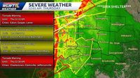
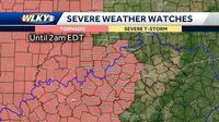
Severe weather swept through the Greater Cincinnati and Louisville areas late Wednesday, April 2, 2025, bringing with it thunderstorms, tornado watches, and the potential for significant flooding. As the storm system moved eastward, residents were urged to prepare for emergency situations, with the National Weather Service (NWS) issuing multiple alerts and warnings.
The NWS in Wilmington issued a tornado watch for virtually all of Greater Cincinnati, which includes Northern Kentucky and Southeast Indiana, effective until 4 a.m. on Thursday, April 3, 2025. A flood watch was also put in place, extending until 8 a.m. on Sunday, April 6, 2025, due to saturated soils and the likelihood of excessive runoff that could lead to flooding in low-lying areas.
As thunderstorms rolled into the Cincinnati area late Wednesday night, they were expected to last into the early hours of Thursday morning. Meteorologist Ashley Novak indicated that severe storms were anticipated to hit the region around 1 a.m., lasting for about one hour. Heavy downpours, damaging winds, and the possibility of hail were all concerns. "Keep precautions in mind, heed any warning," Novak advised.
In Kentucky, Governor Andy Beshear declared a state of emergency ahead of the anticipated severe storms, expressing particular concern for the high risk of tornadoes in western Kentucky. The executive order allows officials to coordinate emergency responses and mobilize the Kentucky National Guard. "Remember, these can be strong tornadoes, EF-2 and greater," Beshear stated. "We’re really concerned about people’s safety, especially in the overnight, because when storms or tornadoes hit while people are asleep, that’s sadly when we’ve lost the most people. So, everybody out there, be really careful.”
In Louisville, the storm system began to impact the metro area around 10 p.m. Wednesday, with tornado warnings issued for Jefferson County, including Louisville, St. Matthews, and Shively, until 12:30 a.m. on Thursday. Reports of a confirmed tornado near Middletown at 12:36 a.m. indicated it was moving northeast at 70 miles per hour. Emergency management also reported injuries in Ballard County, with four individuals injured, one critically, due to tornado-related incidents.
The NWS warned that the area could experience widespread flooding, with rain totals expected to reach between 8 to 10 inches, and some portions of western Kentucky possibly seeing up to 15 inches by the weekend. Heavy rainfall could lead to significant flooding, reminiscent of the devastating floods that struck the region earlier this year.
As the storm system progressed, tornado warnings were extended to several nearby counties, including Bullitt, Hardin, Oldham, Trimble, and Henry counties, as well as parts of Southern Indiana. Residents were urged to take shelter, and those in flood-prone areas were advised to monitor conditions closely.
In Ohio, a similar weather pattern was unfolding as the NWS issued a tornado watch for Columbus and central Ohio, effective until 4 a.m. on Thursday. The storm system was expected to bring heavy rainfall, with estimates of 4 to 6 inches across the region through the weekend. Some areas may also face the risk of tornadoes and strong winds.
The NWS has emphasized the importance of being prepared for severe weather, particularly during nighttime tornadoes. Residents are encouraged to have multiple ways to receive weather alerts, such as NOAA weather radios and local emergency alert systems. It is also vital to have a safe place identified in advance, ideally a basement or an interior room without windows, equipped with an emergency supply kit.
As the severe weather continued to unfold, local agencies and officials were working tirelessly to ensure the safety of residents. The Kentucky Derby Festival announced the postponement of the Zoeller Pump Company ParadeFest, initially set for Saturday, due to the anticipated severe weather conditions.
In the face of these challenges, both Cincinnati and Louisville residents are reminded to stay vigilant and informed as the storm system continues to develop. With the potential for severe storms, flooding, and tornadoes, community safety remains a top priority.
As the night progresses, updates from the NWS and local news outlets will provide crucial information for those in the affected areas. Residents are encouraged to follow official channels for real-time updates and to heed any warnings issued by weather authorities.


