Millions of people across the central United States are under tornado alerts as severe storms wreak havoc, causing power outages and raising the threat of tornadoes. As of Sunday, March 30, 2025, tornadoes have been confirmed in Michigan and Missouri, and approximately 170 million people from Illinois to East Texas could be affected over the next few days.
March has already seen an extraordinary number of tornado reports, surpassing last year's figures for the same period. The situation is compounded by a volatile weather system that has brought unseasonably warm temperatures, leading to the potential for severe thunderstorms.
Reports of hail the size of golf balls emerged on Saturday, March 29, with severe weather conditions prompting warnings across multiple states. By Sunday night, over 500,000 customers in Michigan were without electricity, along with more than 65,000 in Wisconsin and over 100,000 in Indiana, according to poweroutage.us.
A total of 12 million people were under tornado watches from Indiana to Arkansas by Sunday evening. The National Weather Service issued tornado warnings for parts of northern Arkansas, southern Illinois, southwestern Indiana, western Kentucky, southeastern Missouri, and western Tennessee until 10 p.m. Miami time.
Furthermore, a tornado warning was issued before 7 p.m. Miami time on March 30, set to last until 1 a.m. in northern Kentucky and southwestern Ohio. Intense thunderstorms are expected to roll in after dark, raising concerns for nighttime tornadoes, which studies indicate are nearly twice as deadly as those occurring during the day.
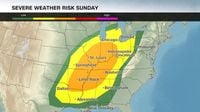
As the storms move eastward, the threat of severe weather will extend into Monday, March 31, affecting nearly 100 million people across the eastern United States. Cities from New Orleans to Boston are included in the risk zone, with destructive wind gusts being the primary concern for the Northeast.
In addition, a powerful line of storms swept into Indiana on Sunday afternoon, bringing dangerous winds and raising the specter of tornadoes. Gusts reaching up to 80 mph have been recorded, prompting multiple tornado warnings across the state.
Indianapolis residents are facing an escalating weather threat as the storms intensify. Over 1,000 power outages have already been reported by Duke Energy in counties like Fountain and Montgomery, where the storms have hit hardest. Local authorities are urging residents to seek shelter away from windows as the risk of destructive winds and tornadoes looms large.
The central part of Indiana remains under a tornado watch until 8 p.m. on Sunday. Winds exceeding 70 mph, combined with the potential for significant hail, are keeping communities like Lafayette and Terre Haute on edge.
By early afternoon, around 3 p.m., the first wave of storms crossed into Indiana, unleashing fierce winds that triggered alerts in counties like Fountain, Parke, and Warren. A tornado warning was issued for Fountain, Montgomery, Tippecanoe, Vermillion, and Warren counties, valid until 4 p.m. The situation escalated quickly, with a severe thunderstorm warning expanding to include Clay, Putnam, and Vigo counties shortly thereafter.
Real-time monitoring of the storms showed winds surpassing 70 mph as they entered the state. By 3:30 p.m., gusts of 80 mph were recorded in specific areas, highlighting the storms' destructive potential. Duke Energy reported over 1,000 homes and businesses without power in western Indiana by 3:47 p.m.
The tornado warning for Fountain, Montgomery, and Tippecanoe expired at 3:53 p.m., but the broader tornado watch remains in effect across central Indiana until 8 p.m. New tornadoes could form at any time, especially in areas with high humidity and converging winds.
Conditions in towns like Attica, Covington, and Veedersburg are particularly tense, with severe thunderstorm warnings active until late afternoon. The intensity of the storms is fueled by the low-pressure system driving chaos across the Midwest.
As the storms continue to progress, residents are urged to take key precautions: seek shelter in sturdy buildings, avoid open areas, and stay informed through weather apps or local broadcasts. Preparing emergency kits with essentials is also advised, especially in areas where severe thunderstorm warnings remain active.
The storms are expected to persist across Indiana into the evening, moving from west to east. After battering western counties, heavy rain and strong winds will likely impact central and eastern regions. The tornado watch will hold firm until 8 p.m., with new alerts possible as conditions evolve.
Urban centers are facing infrastructure challenges, with power grid strains and road safety concerns, while rural Indiana is vulnerable to high winds damaging light structures. The agricultural sector, vital to the state's economy, could also see indirect effects from flooding or prolonged storms.
As the severe weather unfolds, swift action from officials will be crucial to mitigate damage and protect residents. The threat of severe storms is expected to continue into the week, with another round of storms anticipated on Wednesday, April 2, 2025, as temperatures rise again.
In summary, the unfolding weather events across the central United States are a stark reminder of the power of nature and the importance of preparedness. Residents are encouraged to stay informed and take necessary precautions as they navigate this volatile weather pattern.