HOUSTON – A strong storm system is sweeping through Texas on March 28, 2025, creating a significant threat of severe storms and heavy rain. Residents in some areas of Houston are bracing for hefty storms as the day progresses. The Storm Prediction Center has issued a Tornado Watch for parts of Liberty County and Polk County, which will remain in effect until 7 p.m. today.
As the storm system moves through the region, a flood watch that previously affected several Southeast Texas counties has been canceled. This flood watch was in place for Fort Bend, Brazoria, Wharton, Matagorda, Jackson, and Calhoun counties. However, even with the cancellation, isolated heavy rain is still a possibility throughout the day.
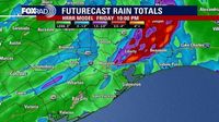
Rainfall totals since Thursday morning have varied, with western Fort Bend County, Wharton, and Matagorda experiencing the heaviest amounts, reaching up to three inches in some areas. Most of the surrounding regions, however, reported between half an inch to one inch of rain. On March 28, residents can expect an additional inch of rain, with isolated locations potentially receiving between two to four inches later in the afternoon and evening. The uncertainty surrounding these totals remains a concern for meteorologists.
The National Weather Service has indicated that off-and-on rain could persist into early Saturday morning, March 29, 2025. Despite the rain, temperatures are expected to remain warm and humid, with highs likely reaching the mid-80s over the weekend. This weather pattern is unusual, as the storms are forming along an upper-level area of low pressure rather than a cold front, meaning that the temperatures will not drop significantly after the rain.
As the weekend approaches, the forecast suggests that the heat index values could reach 90 degrees, making for a very warm atmosphere. While rain is still possible, it is expected to be isolated and short-lived. Highs will remain in the low 80s early next week, with temperatures building into the upper 80s by Wednesday, April 2, 2025. The extended forecast indicates several days in the upper 80s, accompanied by isolated showers.
Residents are encouraged to stay informed about the weather conditions and to download local weather apps for real-time updates. The KPRC Storm Tracker 2 weather app is one option available for those looking to stay ahead of the storm. As Mother Nature can be unpredictable, having access to the latest radar updates is crucial for safety.
In summary, the severe weather threat on March 28, 2025, underscores the importance of preparedness and awareness as residents navigate through heavy rain and potential tornadoes. With the storm system moving through Texas, officials are reminding everyone to take necessary precautions and stay alert for any changes in weather conditions.