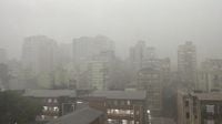
A powerful dust cloud swept through Canoas on the afternoon of March 31, 2025, just moments before a severe storm hit the area. A video captured in the Marechal Rondon neighborhood shows the dust swirling ominously through the central part of the city, setting the stage for the tumultuous weather that was about to unfold.
Minutes after the dust cloud appeared, the storm arrived, prompting alerts from the Civil Defense and the National Institute of Meteorology (INMET). These agencies issued warnings for storms and heavy rainfall across Porto Alegre and the entire Metropolitan Region, effective for both March 31 and April 1, 2025. The conditions raised concerns about potential flooding, landslides, and falling trees.
The first alert from INMET, valid until 6 AM on April 1, predicted up to 50 mm of rain per day, with wind speeds ranging from 40 to 60 km/h and the possibility of hail across Rio Grande do Sul. Although the risk of power outages and flooding was deemed low, authorities advised residents to avoid taking shelter under trees, to keep a safe distance from billboards and transmission towers, and to refrain from using plugged-in electronic devices during the storm.
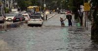
As the storm progressed, a second alert, valid until 11 PM on March 31, indicated a heightened risk of flooding and landslides in vulnerable areas, with rainfall potentially reaching 100 mm in some locations. The Civil Defense urged the public to minimize unnecessary travel, stay vigilant regarding slopes, and disconnect electrical appliances in case of flooding.
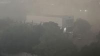
In the heart of Porto Alegre, the storm wreaked havoc shortly after 4:50 PM, bringing winds that reached up to 110 km/h at the Salgado Filho International Airport. The intense rainfall significantly reduced visibility, causing buildings in the historical center to seemingly disappear from sight. Reports of fallen trees and branches flooded in from various locations, including Rua dos Andradas and Rua Gonçalo de Carvalho, where significant damage occurred.
Due to the storm's impact, several water treatment stations—including Moinhos de Vento, São João, and Belém Novo—lost power. The Municipal Department of Water and Sewage (DMAE) confirmed that they were in contact with the local energy provider, CEEE Equatorial, to restore electricity to these critical facilities. However, the outage affected numerous neighborhoods across the capital, compounding the challenges faced by residents.
Traffic disruptions were also reported, with the Public Transport and Circulation Company (EPTC) noting one complete blockage caused by a fallen tree on the intersection of Gen. Salustiano and Riachuelo, alongside two partial blockages due to fallen branches on Rua Dom Pedro II and Av. Nonoai. The situation on the roads was further complicated by traffic lights that were rendered inoperable by the storm.
As the storm continued to unfold, the state was placed under four separate alerts from INMET, highlighting the seriousness of the weather conditions. By the evening, Salgado Filho Airport had temporarily suspended all landings and takeoffs, though operations resumed around 6 PM as the worst of the storm began to subside.
In total, approximately 360,000 locations across the state experienced power outages, with 100,000 affected in the RGE area and 260,000 in the CEEE area. The widespread outages and storm damage led to an urgent response from emergency services, who worked diligently to address the numerous incidents reported throughout the region.
While the storm brought chaos and disruption, it also provided a stark reminder of nature's power. A video captured during the tempest even showed the formation of a marine tornado over the Guaíba, an extraordinary sight amidst the turmoil. As the storm passed, residents were left to assess the damage and begin the recovery process.
The Civil Defense continued to monitor the situation closely, advising the public to stay informed through official channels and to seek safe shelter during severe weather events. With the threat of additional storms in the forecast, authorities urged vigilance and preparedness among the community.
As the week progresses, the focus will shift to recovery efforts and restoring services to those impacted by the storm. Local agencies are mobilizing resources to ensure that power is restored, roads are cleared, and the community can return to normalcy as quickly as possible. The events of March 31 serve as a reminder of the importance of heeding weather warnings and being prepared for unexpected weather phenomena.