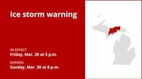
As the Eastern Upper Peninsula braces for a significant ice storm this weekend, residents are urged to prepare for hazardous conditions that could disrupt travel and lead to power outages. The National Weather Service (NWS) issued an ice storm warning early Friday morning, March 28, 2025, at 3:46 a.m. EDT, outlining the expected impact across several counties including Alger, Luce, Delta, and Schoolcraft.
The warning is set to be in effect from 5 p.m. EDT on Friday until 8 p.m. EDT on Sunday, March 30, 2025. According to the NWS, "Significant icing expected. Total snow accumulations up to one inch and ice accumulations between one tenth and one half of an inch this evening through tonight." The forecast further indicates that additional snow and ice accumulations are possible on Saturday night and Sunday.
Specifically, the NWS predicts that ice accumulations could reach up to a quarter inch, with wet snowfall amounts potentially hitting 4 inches during the second phase of the storm. This combination of ice and snow raises serious concerns for power lines and tree limbs, leading to the likelihood of widespread power outages and tree damage.
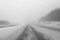
Travel conditions are expected to deteriorate significantly, with the NWS warning that "Travel could be very difficult to impossible." They strongly advise against unnecessary travel, particularly during the Friday evening commute, which could be severely impacted by the hazardous weather.
For those who must travel, the NWS recommends keeping an extra flashlight, food, and water in vehicles in case of emergencies. They caution that roadways, especially bridges and overpasses, are likely to become slick and hazardous. Motorists are urged to use extreme caution and to avoid touching downed power lines.
Phase 1 of the storm is expected to hit from Friday evening through early Saturday morning, with the first signs of icy conditions already affecting the region. Meteorologists have noted that wind gusts of 15-30 mph could accompany the storm, along with the possibility of thunderstorms, particularly during the second phase.
In addition to the ice storm warning for Alger, Luce, Delta, and Schoolcraft counties, a separate ice storm warning has been issued for Chippewa and Mackinac counties, effective from 5 p.m. Friday until 11 a.m. Saturday. This phase is expected to bring greater than a quarter of an inch of ice accumulation, further exacerbating conditions.
Residents are encouraged to stay updated with the latest forecasts and to prepare for the potential impacts of this severe weather event. The NWS emphasizes the importance of being proactive, as the conditions could lead to long-duration power outages and significant disruptions to daily life.
As the storm approaches, local authorities and emergency services are on high alert, ready to respond to any incidents that may arise from the icy conditions. Community members are reminded to look out for one another, especially the elderly and those who may require assistance during power outages.
With the potential for dangerous travel and significant power outages looming over the weekend, it’s crucial for everyone in the affected areas to take the necessary precautions. Whether it’s stocking up on supplies or planning to stay put, being prepared can make all the difference.
As the storm unfolds, residents are advised to monitor local news outlets and the National Weather Service for updates on the weather conditions and any emergency alerts. The safety of the community hinges on awareness and preparedness as this major ice storm approaches.