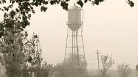
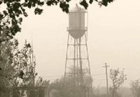
Residents of southern New Mexico and western Texas are grappling with severe dust storms that have led to hazardous conditions on the roads and significant disruptions in daily life. The National Weather Service (NWS) issued multiple dust storm warnings as a dangerous dust storm swept through the region on Thursday, April 17, 2025, prompting the closure of the Interstate between Las Cruces and Lordsburg.
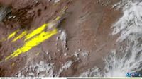
Timelapse satellite imagery released by the National Oceanic and Atmospheric Administration (NOAA) on Friday, April 18, captured the dust storm in action, showcasing its rapid movement across the landscape. The footage, taken during a two-hour period from 12:30 PM to 2:22 PM Mountain Time, illustrated just how quickly the storm developed, with NOAA describing the phenomenon as “dangerous.”
As the dust storm intensified, visibility plummeted in many areas, with reports indicating that some locations experienced visibility of less than 1/4 mile. The high winds associated with the storm gusted up to 65 mph, creating conditions ripe for brown-outs, a term used to describe the suffocating cloud of dust that enveloped the region. El Paso faced its second brown-out of the week on Thursday, leading to significant disruptions.
According to local news reports, the dust storm resulted in at least one fatal crash in southern New Mexico, underscoring the perilous travel conditions created by the blowing dust. With the NWS issuing a Wind Advisory until 8 PM on Thursday and a Dust Storm Warning until 6:30 PM, residents were urged to exercise extreme caution when navigating the roads.
“Blowing dust led to hazardous travel conditions,” NOAA noted, highlighting the risks associated with such extreme weather events. As the dust storm wreaked havoc, meteorologists prepared the public for more unsettled weather ahead. A cold front was anticipated to sweep through the area, bringing colder temperatures and changing wind patterns.
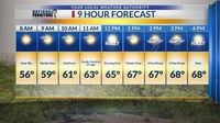
The forecast for Saturday, April 19, 2025, indicates that the weather will remain unsettled as the region braces for another round of dust and wind. Winds are expected to shift from southwest to northwest, gusting near 55 mph. This shift is likely to cause additional blowing dust and a near brown-out by the afternoon. The high temperature for Saturday is projected to be 68 degrees, a stark contrast to the conditions earlier in the week.
By Saturday evening, the winds are expected to die down, and the dust should settle, paving the way for a much more pleasant Easter Sunday. Forecasters predict a bright and sunny day with light winds and a high of 77 degrees, offering a reprieve from the turbulent weather that has plagued the region.
Looking ahead, the weather is set to improve significantly. Monday, April 21, 2025, is expected to be sunny and breezy with a high of 85 degrees. The following days will continue to show a trend toward clearer skies, with Tuesday featuring moderate winds and a high of 87 degrees, and Wednesday expected to be sunny with a temperature of 86 degrees.
While the dust storms have posed challenges for residents, the upcoming forecast offers hope for clearer skies and more favorable weather. As the dust settles and the winds calm, communities can look forward to enjoying Easter activities without the threat of hazardous weather looming overhead.
In summary, the recent dust storms have highlighted the vulnerabilities of southern New Mexico and western Texas to extreme weather events. With the potential for more dust storms in the future, residents are reminded to stay informed and prepared for whatever Mother Nature may bring next.