Seoul's subway system is set to undergo a significant transformation, with the Seoul Metropolitan Government announcing a complete redesign of its individual subway line maps for the first time in 40 years. This announcement, made on April 16, 2025, marks a crucial step toward improving the usability and accessibility of the city’s extensive metro network, which currently spans 23 lines and over 600 stations.
The redesigned maps aim to provide a standardized, user-friendly experience for all passengers, including tourists, seniors, and individuals with color vision deficiencies. The maps will begin rolling out in the second half of 2025, coinciding with the city's efforts to enhance navigation for both locals and visitors.
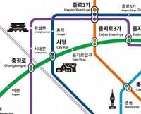
Currently, the subway system employs various maps for each line, which can be confusing due to inconsistent symbols and unclear directions. This has become increasingly problematic as the network has expanded significantly since the opening of Line 1 in 1974, which now stretches 218 kilometers (135 miles) across four metropolitan areas and includes 102 stations.
According to a spokesperson from the Seoul Metropolitan Government, “Current line maps make it difficult to identify key geographic information such as station locations, line direction, and municipal boundaries.” The new design will address these issues by incorporating a unified visual scheme, making it easier for passengers to navigate the subway system.
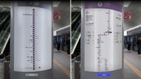
The new maps will be presented in three formats: horizontal, vertical, and square, particularly for screen door placements. One of the most innovative features of the redesign is the introduction of transparent OLED displays at Yeouido Station on Line 5, which will showcase video-based route maps while maintaining visibility. A total of 32 transparent 55-inch OLED panels developed by LG Display will be installed, offering real-time route and safety information.
In addition to improving readability, the new maps will feature color schemes that are more accessible to colorblind users, signal-style markings for transfer stations, and multilingual station numbering. Geographic indicators, such as the Han River and city boundaries, will also be included to enhance navigation.
Furthermore, the redesigned maps will incorporate pictograms representing 14 of Seoul’s iconic tourist destinations, including Seoul City Hall, Dongdaemun Design Plaza, and N Seoul Tower. A city spokesperson noted, “We referred to how Paris used pictograms to guide visitors to iconic sites and Olympic venues during the 2024 Summer Games.” This approach aims to make the maps not only informative but also visually appealing.
Choi In-kyu, director of Seoul’s Design Policy Division, emphasized that the new maps are intended to be easy to read and visually intuitive. “We expect to apply the new design not just in subway trains and stations but also to merchandise and other uses,” he said.
As part of the initiative, the Seoul Metropolitan Government has developed a new standard design for the subway maps, which will be gradually implemented across the system. The design process involved consultations with the Seoul Transportation Corporation to ensure that the new maps meet the needs of all users.
Choi Sung-ho, chairman of the Seoul Public Design Promotion Committee, remarked, “The single route map is aimed at reflecting the principles of design accompanied by the weak and conveying a unified image of Seoul.” This sentiment reflects the city’s commitment to inclusivity and accessibility in public transportation.
Jeong Jin-yeol, a professor of AI design at Kookmin University, praised the new design, stating, “The single route map with improved design will increase the convenience of Koreans as well as foreigners to use the subway.” This highlights the anticipated positive impact of the redesign on both local residents and international visitors.
The new maps are expected to enhance the overall user experience, reducing the time required for passengers to find their way around the subway system. The city government aims to create an information guidance system that meets global standards, thereby enhancing Seoul's competitiveness as a global urban center.
In addition to improving navigation, the Seoul Metropolitan Government plans to develop related merchandise to further promote the city’s brand. This aligns with the city’s broader strategy to enhance its image as a modern and accessible metropolis.
As Seoul prepares for the rollout of these redesigned subway maps, it is clear that the city is taking significant steps to modernize its public transportation system. By focusing on user accessibility and incorporating innovative technology, Seoul is setting a benchmark for urban transit systems worldwide.
With the introduction of the new maps, the Seoul Metropolitan Government aims to not only improve the daily commuting experience for its residents but also to attract more tourists to the city. The combination of aesthetic design and functional improvements is expected to make navigating Seoul’s subway system a more enjoyable experience for everyone.
In conclusion, the upcoming redesign of Seoul’s subway line maps represents a significant advancement in urban transit design, prioritizing clarity, accessibility, and user experience. As the city moves forward with this initiative, it will be interesting to see the positive effects on both local commuters and international visitors alike.