San Antonio and surrounding Central Texas have been grappling with a series of intense storms since early Wednesday, June 11, 2025, prompting multiple flash flood warnings and a flood watch that remains active through Thursday evening. The region faces a complex weather setup as a trough of low atmospheric pressure interacts with a weak cold front and abundant moisture from the Gulf of Mexico, fueling repeated rounds of heavy rainfall and severe thunderstorms.
The first wave of storms rolled through the San Antonio metro area early Wednesday morning, delivering between 0.4 and 0.8 inches of rain across much of Bexar County, with even heavier amounts near the Hill Country towns of Kerrville and Fredericksburg, where close to 2 inches were recorded. While a brief lull was expected in the afternoon, with temperatures climbing into the upper 80s to near 90 degrees and heat index values pushing into the upper 90s, the respite was short-lived.
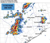
By late Wednesday night, the National Weather Service's Storm Prediction Center (SPC) had placed San Antonio under a Level 2 of 5 risk for severe thunderstorms. These storms, expected to hit hardest between 11 p.m. Wednesday and 7 a.m. Thursday, carried the potential for large hail, damaging wind gusts up to 70 miles per hour, and isolated tornadoes, though the latter was considered less likely. Most concerning, however, was the threat of flash flooding from slow-moving, training storms that could dump over 4 inches of rain in isolated locations.
According to NOAA's Weather Prediction Center, the San Antonio area was included in the "Excessive Rainfall Outlook" with a moderate risk (level 3 of 4) for flooding, underscoring the serious nature of the threat. Local meteorologists have echoed this concern, noting that an in-house computer model is signaling a flash flooding risk especially along the I-35 corridor, where storms with high rainfall rates are expected to develop repeatedly over the same areas, potentially pushing rainfall totals even higher. Although this model is considered an "outlier solution," it has not been dismissed given the atmospheric setup.
As of early Thursday morning, flash flood warnings were in effect for Bexar County until 8:30 a.m., Medina County until 7:00 a.m., and Guadalupe and Comal counties until 5:00 a.m. A broader flood watch extends through Thursday evening for a swath of Central Texas counties including Bandera, Blanco, Caldwell, De Witt, Gillespie, Gonzales, Hays, Karnes, Kendall, Kerr, Lavaca, Llano, Medina, and Wilson.
Northwest San Antonio bore the brunt of the heaviest rain, with up to 6 inches recorded by Thursday morning. Storms training over this area rendered several roads impassable, severely impacting the morning commute. The I-35 corridor, a major artery through the city, was also drenched, causing significant slowdowns. Forecasters advised residents to exercise caution, avoid low water crossings, and consider delaying travel until conditions improve. Fortunately, the storms were expected to wind down by 8 a.m. Thursday.
Looking ahead, Thursday afternoon appears quieter as the upper-level low pressure system responsible for the recent storms begins to move away. While rain chances will decrease, isolated storms remain possible through the weekend, with overall precipitation probabilities dropping to about 20% by Saturday and Sunday. Temperatures will climb back into the mid-90s by the weekend after a brief cool-down.
Despite the easing of severe weather risk, the National Weather Service highlights that San Antonio still faces a 32% chance of accumulating at least 3 inches of rain through the end of the week, with about a 30% chance of exceeding that amount. The odds are even higher moving north into the Hill Country, where more substantial rainfall is expected.
On the day of June 11, the NWS had forecast a 60% chance of showers and thunderstorms throughout the day and into the evening, with new rainfall amounts generally between a tenth and a quarter of an inch, though higher amounts were possible in thunderstorms. The greatest risk for isolated to scattered severe storms was anticipated along the I-10 corridor, including areas east of San Antonio.
In summary, Central Texas residents have been navigating a challenging weather pattern marked by heavy rain, flash flooding, and severe storms. The combination of atmospheric dynamics and tropical moisture has created conditions ripe for flooding, particularly along the I-35 corridor and in the Hill Country. Authorities continue to urge caution, especially during morning and overnight travel, as the region remains on alert through Thursday evening.
As the storms gradually subside, the community will be watching closely for any lingering showers and storms over the weekend, mindful that isolated downpours could still exacerbate already saturated areas. With the upper low retreating and temperatures rising, the focus will shift to recovery and monitoring for any additional weather threats on the horizon.