Authorities in Japan are forecasting rough weather conditions across the country as a low-pressure system moves through, bringing with it strong winds, rain, and snow. On Wednesday, March 19, 2025, weather officials are issuing warnings about potential disruptions from stormy conditions that could affect transportation and daily activities.
The Japan Meteorological Agency indicated that the low-pressure system is advancing westward toward the Sea of Japan. Reports noted gusts reaching a maximum of about 100 kilometers per hour in Tanegashima Island, Kagoshima Prefecture, just before 6 p.m. on Tuesday, March 18, 2025. This extreme wind activity is expected to intensify as the system moves and causes additional disturbances over the next couple of days.
Heavy snowfall is also anticipated, particularly in mountainous regions including Kyushu, Chugoku, and Shikoku. Officials have warned that snowfall has already become significant in these areas, driven by a cold air mass affecting Japan. Conditions are expected to worsen, with forecasts suggesting as much as 40 centimeters of snow accumulation in the Chugoku and Kanto-Koshin regions alone over the next 24 hours.
This winter storm is projected to continue impacting regions of western Japan. By Wednesday, March 19, heavy snow will spread to the eastern and northern parts of the country. The Chugoku, Kanto, and Tohoku regions might experience strong winds of up to 83 kilometers per hour, while northern Kyushu could see sustained winds of about 72 kilometers per hour.
The impact of this storm has already begun to be felt, with reports emerging on Tuesday of vehicular challenges in Aso City, Kumamoto Prefecture, where vehicles became stranded due to heavy snowfall. Specific areas have reported cars stuck on National Route 212 and Prefectural Route 339, particularly leading to the scenic Daikanbo lookout. Police have received distress calls notifying them of up to 30 cars immobilized on Route 339.
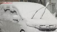
In eastern Japan, residents in the Kanto-Koshin region, which includes metropolitan Tokyo, are also bracing for the storm's heavy snowfall. As the cold air influx continues, regions that rarely see snow are expected to experience these conditions. For instance, Chichibu City in Saitama Prefecture recorded two centimeters of snow in merely three hours leading up to 6 a.m. on Wednesday.
Current snowfall in the Kanto-Koshin region alone is notable, with data showing 20 centimeters of fresh snow accumulating in Kusatsu Town, Gunma Prefecture, while Okunikko in Tochigi Prefecture received 16 centimeters in the same period leading up to the morning of the storm.
Officials indicate that conditions are ripe for significant snow accumulations: snowfall in Tohoku and Tokai regions could reach up to 30 centimeters, while Kanto-Koshin and Hokuriku regions might see 25 centimeters. Further south, Kinki, Chugoku, and northern Kyushu could experience about 15 centimeters. Surprisingly, even the plains of southern Kanto are predicted to receive around three centimeters.
The Japan Meteorological Agency is encouraging the public to remain vigilant, cautioning that dangerous conditions may arise due to heavy snow and strong winds. For those in urban areas, Tokyo's 23 wards might be lightly dusted with about one centimeter of snow, but officials still urge residents to be careful during commuting hours.
The agency observes how ongoing weather patterns this March are significantly affecting everyday life across Japan. With temperatures in southern Kanto dipping lower than anticipated, the rain that initially fell has transitioned into snow across broader areas. This uncharacteristic weather phenomenon is affecting major transportation services and leading to traffic disruptions.
As officials keep scrutinizing the trajectory of these low-pressure systems, they anticipate further complications stemming from these storm systems. The shifting patterns and how they integrate with local geography will continually influence weather outcomes across the island nation.
As the storm progresses, citizens are being urged to monitor updates closely and exercise caution on the roads. Government services are actively working to clear transportation routes but expect challenges ahead, particularly in mountainous regions where the snow accumulation has already begun causing obstructions.
In summary, Japan is entering a significant weather phase driven by low-pressure systems that promise to exert weather extremes. The ensuing rough weather, which spans from northern to western Japan, is expected to heighten in intensity over the coming days, reshuffling daily routines and highlighting the need for public awareness and preparation for severe winter conditions.