HOUSTON – Much like what we’ve seen over the last week, we’re under another Red Flag Warning for Thursday afternoon and evening. Here’s what you need to know: To mark the start of the Vernal Equinox, two cold fronts passed through SE Texas Wednesday, giving us a bit of Deja vu. While we’ll still be warm Thursday, extremely low relative humidity coupled with breezy north winds keep us under another Red Flag Warning behind the fronts.
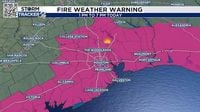
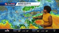
A Red Flag Warning is in effect from 1 PM to 7 PM on Thursday. We’ll see the strongest wind gusts lasting through the afternoon hours as a high-pressure system settles over the Lone Star State, allowing full sunshine to warm up our atmosphere. High pressure causes the air to sink, which in turn, helps to create vertical mixing. Winds in the upper levels of the atmosphere are strong, and with the mixing, those winds find their way to the surface. Winds will gust anywhere from 20-25 mph Thursday.
After the sun sets this evening, you’ll notice the winds will calm down as they shift to the south by Friday. Because of the Red Flag Warning, any fires that do start, are going to be difficult to contain. We have a moderate to very high level of fire danger for Thursday. An ongoing fire is already occurring in portions of the Sam Houston National Forest. As of 11:37 AM Thursday, the Pauline Road Fire is up to 2,000 acres and only 20% contained. It is recommended that all outdoor burning is put on hold for Thursday.
NEW ORLEANS (WVUE) - The National Weather Service issues Red Flag Warnings when the weather pattern promotes the erratic behavior of wildfires. It doesn’t mean wildfires are present, but that if one starts, it may become hard to control - posing a threat to life and property. When the weather pattern is particularly windy and dry, it triggers the warning. The criteria for a Red Flag warning differs across the country based on the local climate. For instance, a hot and dry location like Phoenix, Arizona will have different fire weather criteria than a more warm and humid climate like New Orleans, Louisiana.
Drought also plays a role in issuing Red Flag Warnings. When there is dry vegetation on the ground, a Red Flag Warning may be issued easily when the winds are strong and humidity is low. According to the National Oceanic and Atmospheric Administration (NOAA), the term ‘Red Flag Warning’ has been used since the 1960s. Many locations around the country use red flags to alert the local public of fire danger - much like how beach flags are used to alert swimmers of rip currents.
A Red Flag Warning is issued when dry and windy conditions are expected within 24 hours. A Fire Weather Watch is issued when fire weather or a Red Flag Warning is anticipated within 72 hours.
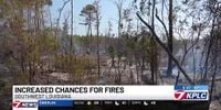
LAKE CHARLES, La. (KPLC) - Today’s higher wind gusts and dry air in Southwest Louisiana have made it more favorable for chances of a fire. “We’re just asking people to refrain from any and all outside burning. Don’t light your little burn piles just yet give spring a little bit more time to come in a little more rain, a little more green and then we can rake our leaves up, clean up our yards up like we like to do in the spring time and then we can burn,” said Houston River Fire Chief Dean Lappe.
Lappe says when it comes to a red flag warning, his station makes sure all the proper equipment is ready. “One of the first things we do is we get all of our brush equipment, all of our brush buggies, our brush trucks, everything that we need to fight a brush fire with, or a woods fire, grass fire, we get all that equipment running, make sure all the tanks are topped off, and all the fuels are topped off,” said Lappe. The National Weather Service of Lake Charles in a statement says to avoid activities that cause flames or sparks, properly discard cigarettes, avoid parking on dry grass and check trailers for dragging chains.
On Thursday, March 20, Southwest Louisiana was under a Red Flag Warning due to similar conditions. By that time, the Norman Weather Service had issued the warning for all of the Northshore, River Parishes, and portions of the Bayou. “We have a high fire danger, and it runs until 7 p.m. tonight. Winds are coming from the northwest at 15-20 mph with gusts up to 30+ mph,” the station reported.
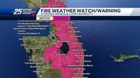
A Red Flag Warning has also been issued for Palm Beach County and the Treasure Coast in Florida, where conditions are similar. The high fire danger goes into effect from 11 a.m. until 8 p.m. with low humidity and high winds contributing to the risk. Winds in this area are expected to gust up to 25 mph, and temperatures could reach the mid-80s during the day.
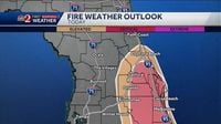
In Central Florida, the combination of gusty winds and dry vegetation has placed several areas under a Red Flag Warning. Starting from 11 a.m. and lasting until 8 p.m. on March 20, these conditions have raised awareness pertaining to fire danger across the state. Officials are currently battling a brush fire that had previously cut off access to the Florida Keys.
As fire season approaches in many parts of the country, forecasters are warning residents to stay vigilant about outdoor burning due to erratic wildfire conditions. Authorities urge residents to stay safe by avoiding any activities that could spark a fire, as the climate continues to create ideal conditions for wildfires to ignite and spread rapidly. As this warning is in effect, the public is encouraged to stay informed and prepared in the event of changing weather conditions.