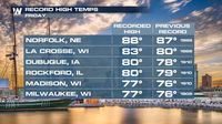
A strong area of high pressure has built east into the Plains and Upper Midwest, leading to warm-to-hot temperatures across much of the country. On Friday, March 28, 2025, record temperatures were set, with many regions experiencing unseasonably warm weather. However, a swift change in conditions is on the horizon as a low-pressure system approaches, bringing cooler air from the north.
As the weekend arrives, temperatures are expected to drop significantly. For instance, Rapid City is forecasted to experience a high of only 30 degrees Fahrenheit on Saturday, March 29, 2025, a stark contrast to the warmth felt just a day prior. Similarly, Sioux Falls will see a drastic shift, plummeting from highs in the low 80s on Friday to just 42 degrees on Saturday.
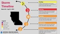
Moving into Sunday, March 30, 2025, a brief lull in weather activity will be observed with dry conditions dominating the area. However, this calm will be short-lived as the next storm system is set to arrive, bringing widespread rain and heavy mountain snow. This system is expected to persist into Tuesday evening, April 1, 2025.
Weather forecasts indicate that a Winter Storm Watch has been issued for elevations above 4,000 feet, effective from 11 PM on Sunday, March 30, 2025, until 11 PM on Tuesday, April 1, 2025. Meteorologists predict that areas at higher elevations could see snowfall totals ranging from 1 to 3 feet, with the possibility of up to 4 feet in the highest peaks. Snow levels are anticipated to drop to around 3,000 feet early Tuesday morning, with an additional 1 to 4 inches of snow expected at those altitudes.
In addition to the snow, there is a chance of thunderstorms developing in the afternoon and evening hours, particularly on Monday, March 31, 2025. The likelihood of isolated thunderstorms is estimated to be around 10% to 20%, especially in the northern Sacramento Valley and northeastern foothills. Gusty southerly winds are also forecasted for Sunday and Monday, with gusts exceeding 40 mph in some areas.
While the first storm system will bring significant moisture, the second system arriving late Tuesday night into Friday morning, April 4, 2025, is expected to be somewhat weaker. Despite this, moderate snow impacts in the mountains are still anticipated, though the exact precipitation totals and impacts for the valley areas remain uncertain.
As residents prepare for the upcoming weather changes, it is essential to stay updated on forecasts and advisories. The rapid fluctuation from warm temperatures to potential winter weather highlights the unpredictable nature of spring weather in the Plains and Upper Midwest.