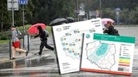
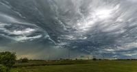
As temperatures rise across Poland, the country braces for a series of thunderstorms and unpredictable weather patterns. The Polish Institute of Meteorology and Water Management (IMGW) has issued warnings for various regions, predicting that conditions will be conducive to storm formation, especially from Lower Silesia through Greater Poland to Warmia. The storms are expected to bring heavy rainfall, with accumulations of 10-15 mm and wind gusts reaching up to 50 km/h in some areas.
On Monday, April 14, 2025, the weather forecast indicates a mix of moderate to heavy cloud cover, with temperatures varying significantly across the country. In the northeast, temperatures are expected to peak at around 21 degrees Celsius, while the western and southern regions may see highs of up to 23 degrees Celsius. However, coastal areas will remain much cooler, with temperatures dropping to as low as 9 degrees Celsius on the Hel Peninsula.
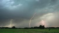
The storms are not expected to be severe, as they are described as generally weak and short-lived. Despite this, the IMGW urges residents to remain cautious, particularly in areas where thunderstorms are likely to develop. As of mid-afternoon, there were reports of three active storm cells: one near the Tricity area and the Gulf of Gdańsk, another near Chojnice, and a third around Chełmno and Grudziądz. These storms are moving northeast at speeds of 30-40 km/h, and more storm cells may form, particularly in the Warmia-Masuria region.
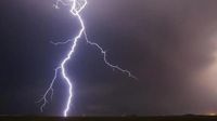
In terms of precipitation, it is expected that rainfall will be significant during storms, with totals of up to 15 mm possible in some areas. The IMGW has also indicated that localized hail could accompany these thunderstorms, adding to the unpredictable nature of the weather.
As the day progresses, residents in the Łódź region can expect potential thunderstorms in the afternoon, particularly in the northern parts near Kutno, and later in Poddębice and Uniejów. Evening thunderstorms may also develop in Łowicz, Skierniewice, and possibly in Zgierz and Łódź itself.
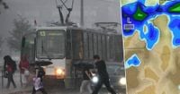
The overall weather conditions in Poland are shifting, with the arrival of a Scandinavian low-pressure system bringing cooler air and instability to the region. This change marks a stark contrast to the warm and sunny weather experienced over the weekend.
As meteorologists analyze the situation, they explain that storms form when cold and warm air masses collide, creating the necessary conditions for thunderclouds to develop. The phenomenon is particularly pronounced in urban areas, which often act as heat islands, warming up more quickly than surrounding rural areas. This rapid heating can lead to an increase in storm activity, as the vertical movement of air is intensified by the presence of tall buildings.
In addition to thunderstorms, the forecast for the following day, April 15, indicates that the weather will remain changeable with conditions conducive to further precipitation. Morning fog may reduce visibility to 500 meters in some areas, particularly in the northeast and central regions. The maximum temperature is expected to range from 16 degrees Celsius in the southeast to about 22 degrees Celsius in the northwest.
With the arrival of spring, many residents are left wondering how to prepare for the storms. The IMGW advises individuals to stay informed by checking live storm radar updates, which can provide real-time information on the location and intensity of storms. This is especially important given the unpredictability of storm development in the current weather conditions.
As these weather patterns unfold, the public is reminded of the importance of safety during thunderstorms. The IMGW provides guidelines for what to do when caught outdoors during a storm, emphasizing that using mobile phones during a thunderstorm can be dangerous.
In summary, as Poland experiences a shift towards warmer spring weather, the accompanying thunderstorms serve as a reminder of the volatility of nature. With temperatures rising and conditions becoming favorable for storm development, residents are urged to stay vigilant and prepared for the changing weather.
For those interested in tracking the storms and understanding more about their formation, the IMGW offers resources and updates that can help keep the public informed and safe during this stormy season.