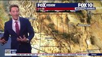
PHOENIX — As spring eases into the Valley, residents should brace themselves for a rapid warm-up that could lead to record-breaking temperatures this upcoming week. According to Isaac Smith, a meteorologist with the National Weather Service in Phoenix, the increasing heat is attributed to a robust ridge of high pressure settling over the desert Southwest. "We’re going to see a warming trend continue for the rest of this week into next week," he said.
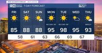
The swiftly changing conditions mark a noticeable shift from the cooler temperatures of winter. Starting on March 22, temperatures are expected to rise significantly, with highs surpassing seasonal averages. Residents can expect clear and sunny skies throughout the weekend, with projected afternoon highs reaching into the mid to upper 80s, followed by even higher temperatures as early as Monday.
Looking ahead to next week, forecasts suggest a high of 94 degrees for Monday, March 24, which ties the record set in 1990. The heat intensifies on Tuesday, March 25, with a possible high of 98 degrees—breaking the previous record of 96 degrees established just three years earlier. Smith noted that there’s even a chance for the temperature to hit 100 degrees, adding, "We're going to be pushing pretty close to 100 next week," with a 20% likelihood of that occurring.
The anticipated warm-up not only marks an early start to summer-like conditions but also raises questions about the overall temperature trends in Phoenix. Normally, the first 100-degree day of the season does not occur until early May, but this shift indicates an unusual beginning to spring. The earliest recorded day that exceeded 100 degrees was back on March 26, 1988, and next week’s predictions may push boundaries once more.
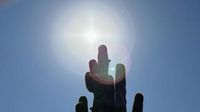
In light of these rising temperatures, Smith urged residents to prioritize heat safety. "Remember to stay cool, stay hydrated, limit your time outdoors," he said. While temperatures may not yet reach the extreme highs of summer, even the 80s and 90s can exacerbate health risks for individuals unaccustomed to such heat early in the season.
Furthermore, rainfall totals for the year have been disappointing, with Phoenix experiencing only 0.87 inches of rain so far, which is 1.48 inches below the average. This dry spell is compounded by changing rainfall averages over the years; according to recent data, the average yearly rainfall in Phoenix has decreased from 8.03 inches to 7.22 inches over the last several decades.
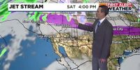
This persistent drought trend continues even as the National Weather Service looks at prolonged warmer and drier conditions across much of Arizona and the Southwest. Forecasts suggest little chance of rain on the horizon, emphasizing the importance of staying hydrated and cautious as heat conditions escalate.
As Phoenix bids farewell to its winter chill, residents must remain cognizant of the risks presented by unseasonably high temperatures. By preparing adequately for the soaring heat, both residents and visitors can navigate the transition into warmer months safely. With discussions surrounding climate change growing increasingly relevant, events like these serve as vital reminders of the unpredictable weather patterns that continue to unfold in our local environment.
As the Valley gears up for a hot stretch ahead, keep an eye on local weather updates and stay informed about any changes in conditions. Whether you’re enjoying outdoor activities or simply staying indoors, it’s crucial to keep the upcoming heat in mind and stay prepared.
With temperatures soaring and records potentially falling, the first full week of astronomical spring is shaping up to be more like summer. Residents are advised to remain vigilant as the warm weather unfolds in the Valley.