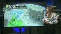
The first weekend of astronomical spring felt like a continuation of the same old pattern across Ontario as an active system moves through the region. A Montana low, tracking in from the Rockies, is expected to bring accumulating snow to much of southern Ontario late Sunday into early Monday. Drivers are urged to beware of slick spots and to check highway conditions before heading out as snow is forecasted to impact travel.
An unusually chilly air mass by late-March standards has swept across northern Ontario, with temperatures plunging below -30°C in Weagamow Lake on Saturday morning, March 22, 2025. This frigid weather is approximately 15 degrees below seasonal norms for this time of year, and residents are feeling the bite of winter as the cold air shifts into northeastern Ontario.
Looking ahead, wet snow is predicted to develop late Sunday evening across the Greater Toronto Area (GTA), with the heaviest accumulations expected to hit north of the QEW, including areas along Highways 401 and 400. The snow will begin to fall where temperatures hover around the freezing mark, potentially delivering a few centimeters to the region. For areas away from Lake Ontario and situated at higher elevations, accumulations could reach up to 5 cm.
Generally, a more disorganized weather system is set to move into eastern Ontario, including Ottawa, during the overnight hours from Sunday into Monday. Forecasts suggest that totals of 3 to 5 cm are likely across most of eastern Ontario, with locally higher amounts possible near Algonquin along Highways 7, 41, and 60 where up to 10 cm could fall. Cottage country and northeastern Ontario are poised to see the most significant snowfall, with moderate snowfall developing through the pre-dawn hours of Monday, March 24, 2025. Periods of heavy snow may linger around Georgian Bay on Monday morning as the low-pressure system advances northward.
For the cottage country and northeastern Ontario area, accumulations are anticipated to range from 5 to 10 cm, with some locations likely to experience higher amounts due to localized heavier snowfall. As temperatures remain below-seasonal, forecasts indicate that this pattern may persist throughout the final week of March and into the opening days of April, prompting concerns among warm-weather enthusiasts.
Notably, Ontario’s first spring weekend did not embody the season’s traditionally warmer climate, as temperatures dropped significantly. To illustrate, Weagamow Lake recorded a bone-chilling -30.5°C on Saturday morning; Sandy Lake was not far behind at -29°C, and Timmins nearly reached -20°C. Overnight lows heading into Sunday displayed widespread below-seasonal temperatures, which crept into southern Ontario, thus leaving the region in the icy grip of winter.
Historical records reveal that this isn’t the first time that Ontario has faced such low temperatures in spring. Last year, for instance, Weagamow Lake experienced five consecutive days of temperatures below -30°C from March 20 to 24, and in March 2014, Timmins recorded temperatures hitting -30.2°C as late as March 26. Even more striking, Timmins faced some of the coldest April temperatures recorded in Ontario, hitting -29.4°C on April 1, 1964. Furthermore, a brutal cold snap in April 1923 set all-time low-temperature records for cities across Ontario.
Despite the current chill, reports caution against dismissing the possibility of warmer weather arriving soon, as forecasters are closely watching low-pressure systems that could bring bursts of warmer air to the region. However, for now, Ontario remains firmly entrenched in winter’s icy grasp, a frosty reminder that just because the calendar marks the arrival of spring does not mean Mother Nature complies.
In conclusion, colder-than-normal temperatures and a return to wintry weather are expected across Ontario as a Montana Low moves in, bringing with it the potential for snowfall, particularly in northeastern regions. With Spring officially underway, the sharp contrasts of weather patterns serve as a reminder of the turbulent and unpredictable nature of Canadian springtime weather.