As the second week of April unfolds, a significant winter storm is set to blanket Ontario, bringing with it accumulating snow, gusty winds, and a sharp drop in temperatures that will make the province feel more like mid-January than spring. According to The Weather Network, a compact low-pressure system is moving across the Great Lakes, resulting in snowfall warnings across various regions.
Starting Monday, April 7, 2025, temperatures are expected to plunge between 10 to 15 degrees below seasonal averages, allowing snow to accumulate across parts of Ontario. This Arctic air mass will not only chill the air but will also trigger lake-effect snow, particularly in areas near Georgian Bay and Lake Huron, where residents can expect heavy bursts of snow.
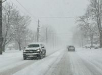
In northern Ontario, snowfall warnings have been issued, with forecasts predicting total accumulations of 15 to 25 cm by Tuesday morning, April 8, 2025. Sudbury is set to be one of the hardest-hit areas, with peak snowfall rates reaching 3 to 5 cm per hour, leading to reduced visibility and hazardous travel conditions.
As the storm progresses, heavy snow is predicted to push east toward the Ottawa region by Monday night. Environment Canada has warned that the combination of snow and strong winds could result in whiteout conditions, particularly in the northeastern parts of the province.
Travelers are advised to be cautious, as conditions may deteriorate quickly. The snowfall will begin in the Sudbury area early Monday morning before moving east into central Ontario by the afternoon. Snow is expected to taper off to flurries overnight into Tuesday morning.
In addition to the snow, strong northwesterly winds are anticipated along Lake Huron and Georgian Bay, with gusts reaching 60 to 80 km/h. In Prince Edward County, winds could also reach similar speeds, while the Greater Toronto Area may experience widespread gusts of 40 to 60 km/h, with occasional gusts as strong as 70 km/h.
Temperatures on Tuesday, April 8, will remain frigid, with wind chill values plunging into the minus double digits across southern and eastern Ontario. The upper atmosphere is expected to dip to minus 17 degrees Celsius, a stark reminder of winter's grip.
For residents in Sudbury and the surrounding districts, all school buses have been cancelled due to the severe weather, although schools will remain open. Parents are reminded to transport their children to and from school as necessary.
As the storm intensifies, the combination of heavy snow and strong winds is likely to make travel along major highways, including Highway 11 and Highway 17, hazardous. Drivers are encouraged to monitor road conditions closely and to adjust their travel plans as necessary.
While this weather system may feel like a cruel joke from Old Man Winter, meteorologists assure that the cold snap will not linger long. Seasonal temperatures are expected to return to Ontario by the end of the week, offering a reprieve from the wintry conditions.
As residents brace for the incoming snow, it’s a good time to remember Sudbury's snowy history. The city once recorded over 55 cm of snow during a late-season storm in April 1975. While this week's storm may not break any records, it certainly serves as a reminder that winter is not quite finished with Ontario yet.
For those venturing outdoors, it’s crucial to dress warmly and be prepared for rapidly changing conditions. With visibility likely to be low and wind chills biting, many will find it wise to postpone non-essential travel until conditions improve.
Stay tuned to The Weather Network for the latest updates on the storm and conditions across Ontario. As this wintery blast rolls in, residents are reminded to stay safe and be prepared for the challenges that come with heavy snowfall and blustery winds.