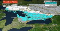
As spring attempts to make its presence felt, many residents across Ontario are bracing for a significant winter blast this weekend. A powerful winter storm is set to bring snow and freezing rain to much of southern Ontario on March 29-30, 2025, prompting weather warnings from Environment Canada.
The storm's impact will be felt widely, covering an area from Sault Ste. Marie in the north down to Guelph in the south and extending eastward to Kingston. Meteorologists are warning that the freezing rain could lead to hazardous conditions, including slippery surfaces, broken tree branches, and potential power outages.
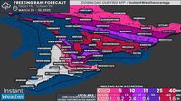
According to Global News meteorologist Ross Hull, the Greater Toronto Area (GTA) is expected to receive between five to ten millimeters of ice accumulation, while regions around Parry Sound, Peterborough, and Kingston could see significant freezing rain, possibly exceeding 25 millimeters. Hull emphasizes that power outages are a major concern in these areas due to the ice buildup.
Environment Canada has issued freezing rain warnings, predicting that the storm will develop on Friday evening, March 28, and persist into Sunday, March 30. The agency notes that conditions will fluctuate between rain, snow, and freezing rain, depending on the temperature fluctuations across the region.
“Areas that change over to rain will see less ice accretion,” the weather agency stated, adding that freezing rain is expected to linger longer in higher terrain where temperatures remain cooler.
As the storm progresses, significant ice accumulation is anticipated, with some areas potentially experiencing ice levels not seen in over a decade. Reports indicate that the hardest-hit regions, including Muskoka, Simcoe County, Kawartha Lakes, and Kingston, could face ice accretion levels of up to 40 millimeters, leading to widespread power outages that may last for days or even weeks.
Travel conditions are also expected to be severely impacted, with ice-covered roads becoming increasingly dangerous. Police have advised residents to avoid unnecessary travel during the storm.
For Northern Ontario, the storm will initially manifest as a classic winter system, bringing heavy snowfall throughout Saturday. Snowfall totals in this region are expected to range from 20 to 30 centimeters, significantly complicating travel.
As the storm unfolds, a second round of precipitation is expected to arrive Saturday night, continuing into Monday. This will likely bring additional freezing rain and ice pellets to areas previously affected, including the Ottawa Valley, where temperatures are predicted to rise, shifting precipitation types.
Environment Canada has warned that the most intense icing conditions are expected overnight into Saturday morning, March 29, with light to moderate freezing rain or drizzle persisting across portions of Central Ontario, particularly around Lake Simcoe.
By Saturday evening, another round of heavy precipitation is anticipated to push into Central Ontario, with temperatures steadily dropping. Models suggest that by late Saturday night into Sunday morning, the freezing rain line could shift southwest of the GTA, potentially bringing several hours of freezing rain to areas like Kitchener, Waterloo, and parts of Toronto.
Sunday morning will likely see a gradual transition from freezing rain to regular rain across the GTA as temperatures climb above freezing. However, elevated areas northwest of the city, such as Guelph, Orangeville, and Shelburne, may experience lingering freezing rain for a few extra hours.
In total, the forecast predicts general ice accretion between 25 and 40 millimeters in the hardest-hit areas, including the northern tip of the Bruce Peninsula, Muskoka, Orillia, Barrie, Orangeville, Collingwood, Lindsay, Peterborough, Belleville, and Kingston.
For the GTA, ice accretion amounts are expected to vary significantly, with northern parts of the region, including York, Durham, and Peel regions, facing between 10-15 millimeters of ice. Kitchener and Waterloo are likely to see between 5-10 millimeters, while areas closer to the Lake Ontario shoreline, including downtown Toronto, should expect lower amounts of around 2-5 millimeters.
As the storm progresses, widespread totals between 20-30 centimeters of snow are anticipated across much of Northeastern Ontario through Monday, including Sudbury, North Bay, Chapleau, Timmins, and Kirkland Lake. Even Thunder Bay could see 10-20 centimeters of snow primarily earlier in the weekend.
With small temperature fluctuations potentially making a massive difference in precipitation types, residents are urged to stay informed and prepared. As this dynamic storm unfolds, the situation will continue to evolve, and updates will be provided as new data becomes available.
As Ontario faces this challenging weather event, residents are reminded to keep their devices charged and stay home if possible over the weekend. The combination of freezing rain and heavy snow poses significant risks, and safety should remain a priority.