A long-duration ice storm is forecasted for parts of Ontario this weekend, with significant snow expected in some regions and heavy ice accretion in others. As the weather system approaches, residents are advised to prepare for hazardous conditions that could disrupt travel and cause power outages.
Beginning Friday evening, March 28, 2025, a potent storm will bring a mix of wintry weather across Ontario. Meteorologists have issued multiple alerts, including snowfall warnings and freezing rain advisories, urging residents to consider postponing non-essential travel until conditions improve.
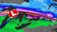
According to forecasts, a sharp contrast between warm air to the south and cold air to the north will generate a variety of wintry precipitation. Snow is expected to develop in northeastern Ontario, pushing along the Ottawa Valley toward the National Capital Region, with potential accumulations of 10-20 cm by Saturday, March 29, 2025. In Ottawa, residents can expect 10-15 cm of snow along with up to 10 mm of ice this weekend, making travel treacherous.
Freezing rain is predicted to develop east of Georgian Bay on Friday evening, affecting communities from Parry Sound to Barrie and Orillia, and extending east toward Bancroft, Peterborough, and Kingston. Parts of the Greater Toronto Area (GTA) may also experience a brief period of freezing rain during the night, with ice accretion potentially reaching 15-20 mm (1.5-2 cm) in the hardest-hit areas. This significant ice buildup will likely lead to dangerously slippery roadways and could weigh down power lines, resulting in localized power outages.
Travel conditions are expected to deteriorate over the weekend, with major impacts anticipated. Residents are advised to check highway conditions and local weather alerts before heading out. The ice storm poses risks not only to travel but also to safety, as extremely slick steps, sidewalks, driveways, and roads can lead to accidents.
On Saturday, March 29, 2025, the threat of icing will continue as freezing drizzle could fall across areas that experienced freezing rain overnight. This additional layer of ice can accumulate, compounding the hazards already present from the initial storm.
As the storm progresses, a Colorado low is expected to track into Ontario, bringing further precipitation. The boundary that caused the first wave of wintry weather will push north through Sunday, March 30, allowing temperatures to rise slightly. However, snow will develop farther north, particularly affecting northeastern Ontario and the Lake Superior shorelines, where up to 40 cm of additional accumulation is possible through Monday, March 31, 2025.
Heavy snowfall is likely to shut down major highways, including Highway 11 and Highway 17 near Lake Superior and Timmins, as more than 40 cm of snow is anticipated. Additionally, freezing rain may linger into Sunday morning across the GTA before temperatures warm in the afternoon. Areas east of the GTA could see freezing rain persist longer, with an additional millimeter or two of ice accretion.
For those in regions that have already experienced ice, another 5 mm of ice accretion is possible, with upwards of 2-5 mm of ice expected for the Ottawa area. This added weight on the snow will create a challenging environment for snow removal.
As the storm system moves through, temperatures could briefly soar into the teens during Sunday night and early Monday, March 31, 2025, ahead of a strong cold front. However, colder weather is expected to return to the region for April 1, 2025, marking a shift back to more seasonal temperatures.
The overall pattern for early April indicates a lack of consistent warm weather, with temperatures expected to remain on the cooler side of seasonal averages for much of the month. Residents are encouraged to stay informed about the evolving weather conditions and prepare accordingly.
In summary, Ontario is bracing for a significant winter storm this weekend, with a mix of snow, freezing rain, and ice leading to hazardous conditions. As always, safety should be the priority, and residents should take necessary precautions to navigate the challenging weather ahead.