As parts of northern Ontario brace for a powerful winter storm, Environment Canada has issued a series of weather alerts for the region, indicating significant snowfall and decreased visibility.
On March 18, 2025, the weather agency issued a winter storm watch alert for various areas including Kirkland Lake, Agawa, Lake Superior Park, and Batchawana Bay, expecting the storm to peak from Wednesday, March 19, into Thursday, March 20. Snow accumulations of 20 to 40 centimeters are expected, with some regions even reporting rates of 3 to 5 centimeters per hour.
Forecast models suggest that precipitation will begin as scattered flurries and showers early Wednesday, before developing into more organized snowfall by midday. The winter storm watch extends to several additional areas such as White River, Dubreuilville, Wawa, and Montreal River Harbour, with the weather anticipated to worsen throughout the day.
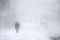
Northerly winds, predicted to gust up to 60 kilometers per hour, will create blowing snow and significantly reduced visibility along highways, particularly on Highway 17, where travel conditions are expected to be hazardous.
Environment and Climate Change Canada (ECCC) has strongly advised residents to avoid travel during this period, emphasizing that weather conditions could lead to transportation delays and safety hazards. "Avoid travel if possible," states the weather alert issued early Tuesday.
This storm appears to be resulting from a Colorado low pulling moisture from the Gulf of Mexico, which will clash with cold air over northern Ontario, producing heavy snowfall as winds from the north and northwest wrap around the system.
In terms of regional effects, locations such as Wawa, Chapleau, Timmins, and Kapuskasing are forecast to see the heaviest totals, with 20 to 40 centimeters of wet snow predicted. Meanwhile, Sault Ste. Marie is expected to start the storm with rain on Wednesday morning, transitioning to snow by Thursday.
The situation in the south contrasts sharply, where warmer temperatures are predominant. Southern Ontario, including areas like Ottawa and Windsor, will enjoy mid to high teens Celsius, providing a stark contrast to the winter conditions across the north. The southern region is likely to remain pleasant until a cold front arrives, potentially leading to rain and possibly thunderstorms late Thursday.
In both regions, the variability of spring weather is becoming apparent this year, as changing conditions have prompted the reevaluation of what typical spring weather looks like across Ontario. Meteorologists warn that while spring is on the horizon, winter is not ready to let go just yet.
As part of the spring forecast, experts encourage Ontarians to stay informed through weather updates this week and into next week, particularly while the storm's impact unfolds.
Ultimately, the potential for hazardous conditions remains significant, and Ontarians are urged to stay safe and plan travel accordingly as the battle between winter and spring intensifies.