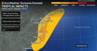
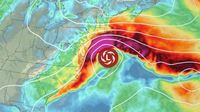
As the weekend approaches, millions along the U.S. East Coast are bracing for the arrival of a powerful nor’easter, a storm system forecast to unleash heavy rain, fierce winds, and hazardous coastal conditions from the Carolinas all the way up to New England. While the Atlantic and Pacific are currently spinning with named tropical storms, it’s this unnamed coastal storm—technically a nor’easter—that’s now drawing the most urgent warnings from meteorologists and government officials.
According to the National Weather Service (NWS), the system began developing off the coast of Florida on Friday, October 10, 2025. It’s expected to intensify as it tracks parallel to the East Coast over the weekend, with its most severe impacts projected between Saturday and Tuesday. The storm’s broad reach means that cities and communities from North Carolina’s Outer Banks through New Jersey and into southern New England could all face significant disruptions.
The hazards posed by this nor’easter are manifold. Coastal flooding, driven by a combination of strong northeast winds and astronomically high “king tides,” is forecast to be one of the most serious threats. These king tides, which occur every fall, have already caused minor flooding along the Florida coast this week, but the incoming storm is expected to amplify the risk considerably. The NWS has issued flood watches, warnings, and advisories from Florida to New England, with forecasters warning that the magnitude of flooding could be highly sensitive to the timing of high tides and the evolving wind field.
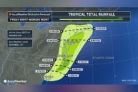
Rainfall totals are expected to be substantial. AccuWeather reports that some areas could see between 4 and 8 inches of rain, especially along the coast from North Carolina to Cape Cod. Even inland areas, including major cities along the Interstate 95 corridor, could receive up to 2 inches, raising the specter of flash flooding in urban centers such as New York City and Philadelphia. The heaviest rain is anticipated from Saturday through Tuesday, with the risk of localized flash flooding wherever the storm’s bands linger.
Wind is another major concern. The storm is forecast to bring sustained winds of 20 to 30 mph, with gusts reaching 60 mph or more in exposed coastal areas. According to Newsweek, these gusts could bring down trees and power lines from southeastern Virginia through southern New England, leading to sporadic power outages. Offshore, waves of 10 to 20 feet and prolonged high surf could cause substantial beach erosion and dune damage, particularly in vulnerable spots like North Carolina’s Outer Banks, which have already seen at least nine unoccupied homes collapse into the Atlantic since late September due to relentless wave action.
High wind watches have been issued for southern Delaware, coastal New Jersey, and Long Island, effective from Sunday morning through overnight Monday. Coastal flood watches stretch from the Outer Banks up to coastal Massachusetts, with moderate to major tidal flooding expected in many locations. In Delaware and southern New Jersey, the National Weather Service in Mount Holly has warned that water levels could rise above 8 feet in Atlantic City on Sunday afternoon—the highest mark since Hurricane Sandy in 2012. Such levels could render roads impassable and flood structures, potentially cutting off neighborhoods until waters recede.
New Jersey’s acting Governor, Tahesha Way, declared a state of emergency beginning at 10 p.m. on Saturday in anticipation of the storm’s arrival. In a statement reported by ABC News and CNN, she urged residents to “exercise caution, monitor local weather forecasts and warnings, stay informed on evacuation protocols, and remain off the roads unless absolutely necessary.” Her warning echoes the broader message from meteorologists: this nor’easter, while unnamed, could be more impactful than any event seen this season in the region.
The storm’s disruptive effects are expected to ripple into air travel as well. Major airport hubs such as Washington, DC, New York City, and Boston could face delays and cancellations due to the combination of strong winds, heavy rain, and low visibility. For those hoping for a quick end to the dreary weather, forecasters caution that the storm may linger just offshore into the middle of next week, with some computer models even suggesting it could loop back closer to the coast after a brief eastward drift.
Beach erosion—a perennial concern during coastal storms—will be exacerbated by the nor’easter’s prolonged high surf and strong onshore winds. The Outer Banks, already battered by recent storms, are likely to see further damage, and significant erosion is possible all along the East Coast up to New England. The combination of rough surf and dangerous rip currents means swimming will be hazardous for hundreds of miles of coastline, prompting officials to urge residents and visitors to stay out of the water.
Flash flood risks are not limited to the coast. The Weather Channel and other outlets note that a Level 2 out of 4 flash flood risk has been issued for coastal North Carolina on Saturday, expanding to include areas from North Carolina through New York’s Long Island—including New York City and Philadelphia—on Sunday. Urban flooding is a particular worry where storm drains may be overwhelmed by the volume of rainwater in a short period.
Forecasters are keen to emphasize the unpredictability inherent in coastal storms. As The New York Times reports, the exact severity and location of the worst impacts will depend on subtle changes in the storm’s strength, track, and timing relative to the tides. “This thing isn’t necessarily going to be named, but it’s still going to be pretty impactful, maybe more impactful than any kind of event that we’ve seen this season, at least up here,” said Matthew Wunsch, a forecaster with the New York City office of the National Weather Service. Nelson Vaz, another NWS meteorologist, added that his office will call it a coastal storm unless it becomes unusually strong, in which case the “nor’easter” label will help people immediately grasp its intensity.
Looking ahead, meteorologists predict that after the storm moves away from the coast later Monday into Tuesday, the East Coast may get a brief reprieve before another round of unseasonable heat sets in by late next week. But for now, all eyes are on the evolving nor’easter and the hazards it will bring. Residents in coastal and low-lying areas are advised to stay alert, heed official warnings, and make preparations for flooding, power outages, and travel disruptions. The next few days will test the resilience of communities up and down the Eastern Seaboard as they ride out another chapter in the region’s long history of coastal storms.