Residents across New Jersey and the broader East Coast found themselves bracing for impact as a powerful nor’easter churned northward over the weekend, unleashing heavy rain, damaging winds, and dangerous coastal flooding. The storm, which began to take shape off the Southeast coast late Saturday, rapidly intensified, prompting emergency declarations, travel disruptions, and a flurry of community action from South Carolina all the way to New England.
On Friday, October 10, 2025, with meteorologists warning of a significant coastal storm, Acting New Jersey Governor Tahesha Way announced the state would enter a State of Emergency at 10 p.m. on Saturday, October 11. The move, affecting all 21 counties, was made “out of an abundance of caution,” she said, and would remain in effect “until it is determined that an emergency no longer exists,” according to WPVI. The nor’easter was forecast to hit New Jersey on Sunday, October 12, and continue through Monday, October 13, bringing with it the threat of up to three inches of rain, wind gusts reaching 60 mph, and the potential for both coastal and inland flooding.
“Starting on Sunday, a dangerous coastal storm will begin to move past our state with extreme weather conditions for several counties, especially those on the Shore,” Acting Governor Way said, urging residents to “exercise caution, monitor local weather forecasts and warnings, stay informed on evacuation protocols, and remain off the roads unless absolutely necessary.” Her warnings were echoed by local emergency officials up and down the coast, who stressed the seriousness of the situation and the importance of preparation.
By Saturday night, as the State of Emergency officially took effect, volunteers and emergency crews sprang into action. In Seabright, Monmouth County, residents filled approximately 1,500 sandbags to protect homes and businesses from the anticipated surge. “It’s nice to see the community come together. I’ve seen neighbors come out and get bags for their elderly neighbors, so just watching people look out for each other, it’s a good thing to see,” volunteer Autumn Nonnenmacher told WABC.
Officials in Cape May County were particularly concerned about the combination of high astronomical tides and the storm’s timing, which threatened to exacerbate flooding and power outages. OEM Coordinator Michael Eck advised residents to move vehicles to higher ground and remove valuables from beachfront properties, noting, “The worst of the tides are going to be happening during daylight hours, so that’s beneficial for us, so we don’t have to operate in darkness, but what we also have working against us is that we have astronomical tides this weekend.”
Despite the dire forecasts, some residents and business owners tried to maintain a sense of normalcy. Anthony Guerriero of Ocean City described the challenge of preparing for the storm while also getting ready for a block party: “Very overwhelming right now because we have a block party going on on the Avenue. So we’re getting ready for a block party and then we’re hit with this.” Meanwhile, Bridget Jacobson, a local business owner, remained optimistic, saying, “Rain or shine, we always draw a huge crowd.” In Medford, Johnson’s Corner Farm was bustling as families sought to enjoy fall festivities before the storm’s arrival. “We’re optimistic. We deal with Mother Nature all the time as farmers, so we’re just going to roll with it and see what happens,” farm owner Gilbert Johnson told WPVI.
But optimism was tempered by the storm’s growing intensity. According to CNN, the nor’easter brought wind gusts over 50 mph to states including North Carolina, Virginia, Maryland, Delaware, and New Jersey by Sunday afternoon. At North Carolina’s Cape Lookout, a gust of 61 mph was recorded, while New Jersey’s Sea Isle City saw gusts up to 59 mph. The National Weather Service warned that strong winds would continue to lash the coast, with some of the most severe impacts expected from New Jersey into southern New England, and gusts as strong as those produced by a tropical storm.
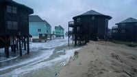
Flooding quickly became a reality. Water levels in Atlantic City reached minor flood stage on Sunday afternoon, forcing the closure of Route 40 and Route 30 in both directions. Projections indicated the flood threat would only climb higher, with levels expected to exceed 8 feet on Monday—potentially the highest since Superstorm Sandy in 2012. Cape May faced a similar fate, with water levels projected to reach over 8 feet, the third-highest on record and the highest since January 2016. The slow-moving storm meant multiple rounds of coastal flooding were likely, raising concerns about inundated roads and homes, and significant beach erosion up and down the East Coast.
Further south, the storm’s impact was already being felt. In Georgetown, South Carolina, authorities rescued several motorists trapped by floodwaters after nearly 10 inches of rain fell in just 24 hours, as reported by CNN. Fortunately, no injuries were reported. North Carolina’s Highway 12 was closed due to ocean overwash, and at least nine unoccupied homes had collapsed into the Atlantic since September 30 because of relentless wave action and erosion. Charleston Harbor reached major flood stage on Saturday, flooding streets and disrupting daily life.
Travelers across the Northeast faced mounting challenges. The Federal Aviation Administration reported ground delays at major airports including Boston Logan, Reagan National, Newark Liberty, Philadelphia, JFK, and LaGuardia on Sunday as the storm’s winds and rain intensified. Some flights were delayed or canceled from Washington, D.C., to Boston, and officials advised travelers to check for updates before heading to the airport.
New Jersey’s utility companies, including PSE&G, performed system and logistics checks ahead of the storm, preparing for the likelihood of power outages. New Jersey Transit services continued to operate on regular schedules as long as conditions remained safe, while residents were urged to bring inside outdoor items like lawn furniture and Halloween decorations to prevent them from becoming dangerous projectiles in the high winds. In New York, Governor Kathy Hochul and city officials assured residents that state workers would be out in full force to respond to any damage. “Areas that are served by overhead power lines, be prepared for potential outages. Our utility partners are bringing out additional crews to make sure they can immediately respond to that,” NYC Emergency Management Commissioner Zach Iscol said, adding practical advice: “But also make sure that you have a flashlight ready with extra batteries, make sure your phone is charged.”
As the nor’easter continued its march north, the National Weather Service issued coastal flood warnings and wind advisories for New York City and Long Island through at least Monday afternoon. Rainfall totals of 1 to 3 inches were expected along the East Coast, with some areas in eastern North Carolina and southeastern New England possibly seeing up to 6 inches. Localized flash flooding was a significant concern, especially in areas that experienced repeated downpours.
Leaders up and down the coast called for vigilance and neighborly care. Maryland Governor Wes Moore urged residents to “ensure their loved ones and neighbors are properly monitoring the potential for high winds, rain, and flooding.” Atlantic City’s Mayor Marty Small Sr. told CNN his city had learned from past storms like Sandy how best to prepare, while Acting Emergency Management Coordinator Michael Famularo captured the prevailing sentiment: “We always prepare for the worst and keep hoping for the best.”
By Monday night, October 13, forecasters expected the storm to finally move out or weaken, with high pressure building in behind it and drier, calmer weather returning to the battered coast. Until then, the East Coast remained on high alert, its communities united in preparation and hope as the nor’easter delivered a powerful reminder of nature’s force.