The 2025 Atlantic hurricane season officially began on June 1 and will run through November 30, with forecasts pointing toward an above-normal season marked by potentially devastating storms. The National Oceanic and Atmospheric Administration (NOAA) predicts a 60% chance of above-average hurricane activity, estimating 13 to 19 named storms, 6 to 10 hurricanes, and 3 to 5 major hurricanes reaching Category 3 or higher.
Experts attribute the heightened activity to a combination of factors, including continued ENSO-neutral conditions, warmer-than-average ocean temperatures, forecasts for weak wind shear, and a potential northward shift of the West African Monsoon. This monsoon is a critical starting point for many Atlantic hurricanes, and its increased activity could lead to more tropical waves seeding powerful storms.
NOAA’s National Weather Service Director, Ken Graham, emphasized the importance of preparedness, stating, “In my 30 years at the National Weather Service, we’ve never had more advanced models and warning systems in place to monitor the weather. This outlook is a call to action: be prepared. Take proactive steps now to make a plan and gather supplies to ensure you’re ready before a storm threatens.”
Technological advancements are set to enhance forecasting and response capabilities this season. NOAA’s flagship Hurricane Analysis and Forecast System (HAFS) has been upgraded, promising a 5-7% improvement in forecasting rapid intensification—defined as wind speed increases of 30 knots in 24 hours. Researchers at NOAA’s Atlantic Oceanographic and Meteorological Laboratory (AOML), in partnership with academic and private institutions, are also deploying new technologies such as small aircraft drone systems, swarms of atmospheric profilers, and underwater gliders to better understand hurricane behavior and improve forecast accuracy.
In addition, NOAA’s National Hurricane Center (NHC) and Central Pacific Hurricane Center will issue tropical cyclone advisory products up to 72 hours before the arrival of storm surge or tropical-storm-force winds, providing communities with more time to prepare. The Climate Prediction Center’s Global Tropical Hazards Outlook has been extended from two to three weeks, offering earlier warnings of potential tropical cyclone risks.
Enhanced communication efforts include the NHC offering Spanish language text products for key advisories and discussions, broadening accessibility for Spanish-speaking communities. An experimental forecast cone graphic will highlight areas with simultaneous hurricane watches and tropical storm warnings inland, helping residents better understand overlapping threats. Additionally, a rip current risk map will be provided when active tropical systems threaten coastlines, addressing the dangers posed by swells from distant hurricanes.
NOAA is also introducing a new experimental electronically scanning radar system called ROARS, deployed on the P-3 hurricane hunter research aircraft. This radar will scan beneath the plane to collect detailed data on ocean waves and hurricane wind structures, further refining forecast models. Moreover, the Weather Prediction Center’s Probabilistic Precipitation Portal offers user-friendly access to rain and flash flooding forecasts up to three days in advance—a vital tool following the extreme rainfall caused by Hurricane Helene in 2024, which dumped over 30 inches of rain in North Carolina, causing deadly flooding.
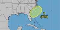
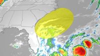
The early days of the season have already seen activity, with the National Hurricane Center identifying a weak low-pressure system offshore the southeastern U.S. coast on June 2. While the chance of development over the next seven days is low—around 10%—this system could gradually acquire subtropical or tropical characteristics as it moves northeastward by June 6 or 7. Regardless of development, stormy conditions are expected from Florida to the Carolinas over the next few days, driven by a stalled front and upper-level disturbance.
Localized heavy rain is forecasted from South Florida, including Miami, through to coastal cities such as Savannah, Georgia; Charleston, South Carolina; and Wilmington, North Carolina. Flash flooding remains a concern, especially on June 3 in South Florida. Meanwhile, beaches along the Southeast coast will face rough surf and rip current risks, prompting warnings for beachgoers to exercise caution.
These early-season disturbances are typical for June, as the Caribbean, Gulf of Mexico, and Southeast U.S. coasts are common areas for tropical developments at this time of year. The first named storm of the season will be Andrea.
Beyond meteorological concerns, the Pan American Health Organization (PAHO) has issued a call for countries in the Americas to review contingency plans and activate preventive measures to prepare health systems for the potential impacts of hurricanes, floods, and other extreme weather events. Leonardo Hernandez, Head of PAHO’s Emergency Operations Unit, highlighted the serious threats posed by such events: “Extreme hydrometeorological events, such as hurricanes, torrential rainfall and resulting floods and landslides, are a constant threat to the region, leading to injuries, loss of life and overwhelming health care systems.”
PAHO further warns of the health consequences that often follow these disasters, including increased risks of water-borne diseases like diarrhea and cholera, vector-borne illnesses such as dengue and Chikungunya, and respiratory diseases. The 2024 hurricane season was particularly destructive, with 18 named storms—including 11 hurricanes, five of which were major—and multiple Category 5 hurricanes, such as Hurricane Beryl, the earliest Category 5 storm ever recorded.
To bolster preparedness, PAHO is organizing a readiness virtual meeting on June 10, 2025, bringing together representatives from Ministries of Health and civil protection agencies to share expertise on disaster response and public health emergency management. The organization continues to assist countries in updating their national emergency response plans and strengthening coordination mechanisms at all levels to ensure timely and effective responses to future alerts.
As the 2025 hurricane season unfolds, NOAA plans to update its Atlantic seasonal outlook in early August, ahead of the historical peak of hurricane activity. Meanwhile, communities along the Atlantic, Gulf, and Caribbean coasts are urged to stay vigilant, heed warnings, and prepare for what experts anticipate will be a challenging season.