The National Geospatial-Intelligence Agency (NGA) has recently selected BlueHalo as a vendor for its Luno B contract, a significant $200 million, five-year initiative aimed at revolutionizing the agency's approach to geospatial information and knowledge. This partnership marks a pivotal step in enhancing the NGA's capabilities to analyze and interpret complex global data.
Under the terms of the Luno B contract, BlueHalo is tasked with delivering critical geospatial data that will provide analysts with data-quantified insights into worldwide economic, environmental, and geopolitical activities. This comprehensive approach not only expands access to data and services but also accelerates modernization objectives and integrates various data sources into the agency's enterprise capabilities.
Brian Morrison, BlueHalo's portfolio president and corporate executive vice president, expressed enthusiasm about the partnership, stating, "BlueHalo possesses extraordinary expertise in acquiring, analyzing, and visualizing multiple data sets — to include open source and commercially available data. By expanding and deepening our cooperation with NGA through Luno B, we’re coupling that expertise with capabilities in artificial intelligence, machine learning, and computer vision to provide unparalleled analysis–equipping our warfighters, policymakers, and mission partners with the decision advantage." This collaboration aims to enhance the understanding of the human domain, particularly in identifying, monitoring, and predicting illegal activities such as human trafficking and environmental exploitation.
In addition to the Luno B contract, BlueHalo was awarded the Luno A contract in 2024, further solidifying its role as a key player in the NGA's modernization efforts. The Luno B initiative is particularly noteworthy as it emphasizes the integration of advanced technologies like AI and machine learning, which are essential in today's rapidly evolving data landscape.
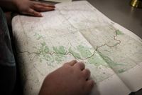
Meanwhile, students at Northwest Missouri State University are gaining valuable experience in the Geographic Information Science (GIS) field through a partnership with the NGA. This collaboration, now in its third year, allows students to work on 1:50,000 scale topographic maps, providing them with profession-based experience while simultaneously enhancing the NGA's map production capabilities to address national security challenges.
Utilizing computer software, Northwest students edit and update maps based on changes to the geologic and cultural landscape. This hands-on approach not only equips students with real-world skills but also contributes to the intelligence community's efforts in producing accurate and timely geospatial information. Northwest Missouri State University is one of only two universities involved in the NGA's academic partnership, alongside Southern Illinois University.
Dr. Brett Chloupek, an associate professor of geography at Northwest, highlighted the significance of this partnership, noting, "It is the exact same work role and the exact same thing that newly hired employees at National Geospatial Intelligence would be doing. It’s impressive to see these students level up to the point where you can really say these are professional cartographers." Since the partnership's inception in 2022, Northwest and the NGA have successfully hired and trained 15 student cartographers, who have collectively produced several hundred topographic maps for the intelligence community.
The map-making process is intensive, with each map requiring between 40 to 100 hours to complete. Kyra Kamp, a geotechnical services analyst for Northwest who graduated last year, shared her positive experience, stating, "The NGA partnership helped me as a student get real-world experience on actual projects before leaving school and allowed me to apply what I learned in my classes to real projects. I learned how to complete large and complex projects on a deadline. I also learned to pay attention to small details and work with specific requirements for each project. The value of this program is huge."
Students must meet specific academic criteria to participate in this partnership, ensuring that they are well-prepared for the challenges of the GIS field. The collaborative nature of the program involves students, faculty, and NGA staff working together, fostering an environment of learning and professional development.
Nikki Welch, a senior geography major from Mexico, Missouri, expressed her enthusiasm for the project, stating, "At first, I did not think I would like it but after the first couple of months, I found that I really did and loved it. Also, this made me want to make a map of my own from start to finish." This sentiment is echoed by many students who find the partnership not only educational but also inspiring as they prepare for careers in geospatial intelligence.
Northwest Missouri State University offers a range of programs in GIScience, including bachelor’s and online master’s degrees, as well as an online graduate certificate program. The university's commitment to providing students with practical experience and opportunities in the field of geospatial intelligence is evident through its collaboration with the NGA.
The NGA's role as a premier public GIS employer underscores the importance of geospatial intelligence in today’s world, assisting policymakers, warfighters, intelligence professionals, and first responders in fulfilling national security priorities. Its topographic maps aid in various operations, including combat, humanitarian assistance, disaster relief, and military training.
As the partnership between Northwest Missouri State University and the NGA continues to evolve, it not only enhances the educational landscape for students but also strengthens the capabilities of the NGA in addressing complex national security challenges. The integration of academic institutions with government agencies exemplifies a forward-thinking approach to workforce development in the critical field of geospatial intelligence.