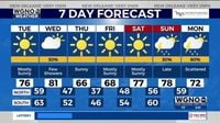
NEW ORLEANS (WGNO) — Residents of New Orleans can expect beautiful weather to continue as they move through the rest of the week. On Tuesday, March 18, 2025, they will see sunny and breezy conditions, with temperatures soaring to the mid to upper 70s. This pleasant weather follows a cool night with temperatures dropping as low as the low 40s north of the city and the mid to upper 40s to the south.
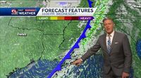
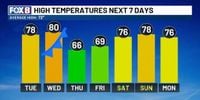
"Highs will jump near 80 degrees today and Wednesday," reported WVUE, forecasting temperatures to climb steadily over the next couple of days. Winds are predicted to pick up from the south, blowing at 15-20 mph, with higher gusts as the area braces for the arrival of a weather system late on Wednesday, March 19. Despite the anticipation of this weather front, the rain is expected to be minimal, with only about a 30% chance of spotty showers.
Weather experts predict some cooling trends will emerge following this front. By Thursday, March 20, mornings will feel almost cold, with temperatures dipping to around 39 degrees north of Lake Pontchartrain. The high temperatures will plummet back to the 60s, offering residents quite the change from the warmth they’ve enjoyed earlier in the week.
Friday, March 21, 2025, is expected to bring similar cool conditions, with highs around 70 degrees; mornings could dip near the freezing mark for those north of the lake. "There’s definitely going to be a chill in the air as we wrap up the work week," meteorologists explained, reminding locals to dress accordingly.
Compounding the weather changes, the National Weather Service recently upgraded the tornado event from Kentwood, which occurred over the past weekend, to an EF4 classification, with wind speeds reaching up to 170 mph. This tornado reportedly traveled over 70 miles, beginning its path through Kentwood and progressing toward Mississippi. Such extreme weather events are becoming increasingly notable as spring begins to set in.
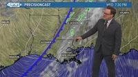
Looking forward, as late Sunday, March 23 and Monday, March 24 approach, another storm system is projected to develop. "Our next storm is setting up for late Sunday, but for now, it looks like our weekend events and parades shouldn't have any major issues," WVUE stated. Rain chances might intensify as we head toward the latter part of the weekend, with increasing humidity factors expected to lead to showers and possible thunderstorms.
The forecast remains ever-changing, typical for the spring season. The arrival of the spring equinox on Thursday, March 20, 2025, at 4:01 AM, signals another transition as warmer months begin to emerge.
Despite the call for possible rainfall, locals can anticipate temperatures to climb almost back to 80 degrees shortly after. Saturday, March 22, 2025, could see highs around 78 degrees, albeit with only slim chances of rain.
It is always wise for community members to stay updated on the weather. The unpredictability of spring often brings rapid changes, but residents can be prepared for the chillier conditions later on.
Overall, expect the warm temperatures to prevail through midweek, followed by cooler weather and occasional rain as the week closes out. For anyone planning outdoor activities over the weekend, keeping abreast of the weather forecast will be beneficial.