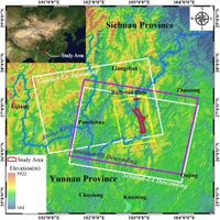
The Baihetan Hydropower Station, located on the Jinsha River, is currently making waves in hydropower operations and geological monitoring. As the world’s second-largest hydropower station, this monumental project faces continuous impoundment, raising concerns regarding reservoir slope stability and safety for surrounding communities. Recent studies deploying advanced InSAR technology and the innovative GACOS atmospheric correction method have shed light on the critical issues of landslide detection and monitoring in this region, highlighting how factors such as water level fluctuations and intense rainfall contribute to slope instability.
The integration of multi-source Synthetic Aperture Radar (SAR) data has proven to be a game-changer in identifying and monitoring landslides in the Baihetan reservoir area. According to the findings, 52 landslides were detected throughout the monitoring period, with 31 of these being newly discovered during the reservoir impoundment from April 6, 2021. The research emphasizes the need for precise landslide mapping and continuous monitoring to mitigate potential hazards associated with large-scale hydropower projects.
The researchers pointed out that the Baihetan Reservoir project, while significant for clean energy production and disaster mitigation, is fraught with geological risks. The water level fluctuations inherent to the operating hydropower facilities can change the mechanical properties of rock and soil, leading to slope instability. Thus, effective landslide detection contributes to the overall risk management of hydropower projects, providing timely warnings and strategies to prevent catastrophic physical and economic losses.
InSAR technology has long been recognized for its capacity to facilitate wide-area, weather-independent monitoring, detecting millimeter-scale displacements of Earth’s surface. However, the study highlights the traditional challenges of atmospheric interference when conducting InSAR measurements, especially in complex terrains like that near the Baihetan Reservoir where humidity can interfere with the accuracy of the data.
The solution presented involves the adoption of multiple sources of SAR data, specifically the L-band ALOS PALSAR and the C-band Sentinel-1A and Sentinel-1B satellites, in combination with the GACOS atmospheric correction model. This sophisticated setup enables more accurate long-term detection of landslides in the area by minimizing atmospheric distortions. The GACOS model utilizes high-resolution meteorological data to account for local weather changes that affect the measurements, thereby enhancing the reliability of the results.
During the research, the landslide activities unveiled varied responses to both water level fluctuations and rainfall. The deformation analysis yielded three major behaviors regarding pre-existing landslides during the impoundment: continuous increase, weakening of existing deformations, and the emergence of new deformations. Particularly of concern are the 22 total landslides with toe slopes in direct contact with water, which pose significant risks during rapid inundation events.
The distribution of the newly detected landslides suggests that they tend to develop primarily in areas with slope angles ranging from 30° to 40° with altitudes between 800 to 1200 meters. Most landslides emerged in non-massive rock strata and were influenced by localized fault systems, demonstrating the complex relationship between geological structures and hydropower activities.
Furthermore, the study outlines the distinct impact that both intense summer rainfall and rapid water level rises have in triggering deformations in active landslides. For example, key landslides like Wulipo and Shimenkan exhibited accelerated displacement just days after the reservoir began operations, indicating a strong correlation between water levels and slope dynamics.
Field validations of the detected landslides confirmed significant correlation between landslide dynamics and external factors. In one remarkable case, the Wulipo landslide revealed a deformation rate of approximately 55 mm/year, while the Shimenkan landslide showed around 30 mm/year. The combination of rapid changes in reservoir water levels alongside seasonal rainfall results in compounded strains on slopes, further exacerbating landslide instability.
Ensuring safety and sustainability in the operations of large hydropower stations like the Baihetan requires constant vigilance and an understanding of the interplay between natural forces and engineered structures. This research adds significant value to disaster management protocols, showcasing the need for utilizing advanced technologies for landslide monitoring in environments susceptible to complex geophysical interactions.
In summary, the effective integration of GACOS atmospheric correction with multi-source SAR data not only advanced the precision of detecting and monitoring landslides within the Baihetan Reservoir area but also provided critical insights into geological behaviors influenced by reservoir operations. These findings serve as a robust framework for future studies focused on similar hydropower projects, ensuring better preparedness against geological hazards while maximizing energy production efficiency.


