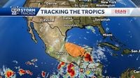
The National Hurricane Center (NHC) is closely monitoring a developing weather disturbance in the northwestern Caribbean Sea that is expected to move into the southern Gulf of Mexico over the weekend of June 28-29, 2025. This system, currently marked by an area of showers and thunderstorms near the Yucatán Peninsula, has sparked cautious attention among meteorologists as it carries a potential for tropical development in the coming days.
As of Friday afternoon, June 27, 2025, the NHC assigned a 30 percent chance that this disturbance could develop into a tropical depression or storm within the next week, an increase from the 20 percent probability noted earlier that same day. The system is forecasted to track west-northwest, moving over Mexico’s Yucatán Peninsula before entering the Bay of Campeche by Saturday or Saturday night.
Computer models suggest the possibility of the system organizing into a closed low-pressure area by Saturday, with further strengthening likely by Sunday. This would mark the formation of a more structured tropical system, potentially leading to the next named storm of the 2025 Atlantic hurricane season, which would be called Barry. So far, 2025’s Atlantic hurricane season has seen only one named storm, Andrea, which formed north of Bermuda and did not impact land.
Despite the potential for development, forecasters emphasize that the disturbance’s progression inland over Mexico by early next week is expected to end its chances of further intensification. Regardless of whether it becomes a named storm, the system is anticipated to bring heavy tropical downpours to parts of Belize, Guatemala, and southeastern Mexico throughout the weekend.
One key factor that may limit the system’s threat to Texas and the U.S. Gulf Coast is the geography of the Yucatán Peninsula. As the disturbance moves over land, it will likely lose strength due to the disruption of wind patterns and the loss of warm ocean waters that fuel tropical cyclones. Sea surface temperatures in the western Caribbean and Bay of Campeche were measured at around 84 degrees Fahrenheit on Friday, which is sufficiently warm to support storm development.
However, the atmospheric environment presents additional challenges for the system’s growth. A massive plume of Saharan dust is currently sweeping across the Atlantic and is forecasted to reach the Texas Gulf Coast by late Saturday. This dust carries dry air that is hostile to tropical cyclone formation and has been a significant factor in suppressing early-season Atlantic storm activity. The arrival of this Saharan dust plume is expected to further diminish the threat posed by the disturbance to Texas, including Houston.
Moreover, high-pressure systems situated over northern Mexico are likely to redirect any tropical activity in the Bay of Campeche inland toward eastern Mexico. This pattern mirrors last year’s events when tropical storms Alberto and Chris formed but dissipated quickly after making landfall in Mexico.
While the disturbance is unlikely to directly impact Texas with significant tropical storm conditions, meteorologists warn that it could still influence weather patterns in the region. The circulation associated with the system may draw tropical moisture northward, increasing rain chances in parts of Texas by Monday or Tuesday. This could bring localized heavy rainfall without the presence of a fully developed tropical cyclone.
Looking beyond this disturbance, the National Hurricane Center is also tracking several tropical waves across the Atlantic basin, including two in the Caribbean. Although the 2025 season has been relatively quiet so far, forecasters from NOAA and other agencies are predicting an above-average hurricane season with a higher probability of named storms than usual.
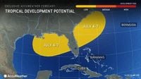
AccuWeather experts have highlighted the potential for tropical development in the Gulf of Mexico or off the southeastern U.S. coast in early July, around the Fourth of July holiday weekend. Warm water temperatures and relatively low wind shear in these areas create favorable conditions for storm formation. However, they caution that the overall chance of development remains low at this time, consistent with typical early-season activity.
Residents in Florida and the southeastern United States should prepare for a wet pattern in early July, with showers and thunderstorms expected to be frequent. Northern Florida and the Panhandle are forecast to receive more rainfall than South Florida during this period, which could affect holiday plans. Additionally, the Saharan dust plume is expected to reach from South Florida to Texas, potentially causing “dirty rain” that leaves residue on cars and surfaces.
The Atlantic hurricane season officially runs from June 1 through November 30, with the peak period of activity traditionally occurring around September 10 and stretching from mid-August to mid-October. The NHC uses the generic term “tropical cyclone” to describe any organized rotating system of clouds and thunderstorms over tropical waters, regardless of its intensity. When maximum sustained winds reach 74 mph, the system is classified as a hurricane in the Atlantic basin.
For now, the developing disturbance in the southern Gulf remains a watch-and-wait scenario. Forecasters will continue to monitor its progress closely, providing updates as conditions evolve. While the system’s development into a named storm remains uncertain, its potential impacts on rainfall and localized flooding in parts of Central America and Mexico are clear. As always, residents along the Gulf Coast and in vulnerable areas are encouraged to stay informed and prepared as the 2025 hurricane season unfolds.