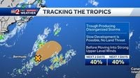
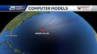
As the 2025 Atlantic hurricane season progresses beyond its first three weeks without any tropical threats, the National Hurricane Center (NHC) has turned its attention to a new system brewing in the central subtropical Atlantic. This area of disturbed weather, a trough of low pressure located roughly 450 to 500 miles east-southeast of Bermuda, is currently producing disorganized showers and thunderstorms. While it poses no threat to land, meteorologists are carefully monitoring its potential development into the season's first named storm.
The NHC reports that this disturbance, often referred to as Invest 90L, has shown some signs of organization as of Sunday evening, June 22, 2025. Satellite imagery has revealed a well-defined surface circulation, a key factor in tropical cyclone formation. These developments have increased the system’s chance of becoming a short-lived tropical depression to about 40% over the next 48 hours, a medium probability that reflects cautious optimism among forecasters.
According to Philippe Papin, a hurricane specialist at the NHC, "Earlier satellite-derived wind data indicated the system possessed a well-defined surface circulation, and additional organization of the shower and thunderstorm activity could lead to the formation of a short-lived tropical depression over the next day or so." This window of opportunity for intensification is expected to last only briefly, as the system is forecast to encounter less favorable conditions by Tuesday, June 24, including increased wind shear and cooler waters, which typically inhibit further development.
Moving northeastward at speeds between 5 to 10 miles per hour, the system is projected to remain over open waters in the central Atlantic, ensuring it will not impact any land areas. The NHC emphasizes that even if the disturbance does develop into a tropical storm, it would not pose a threat to coastal regions. Should it reach tropical storm status, it would be named Andrea, following the convention for Atlantic storms.
This development is notable because the first named storm in an average Atlantic hurricane season typically forms around June 20. The 2025 season, which officially began on June 1 and runs through November 30, has so far been quiet, with no named storms before this point. The last time the Atlantic basin saw no named storms before July was in 2014, when Tropical Storm Arthur formed on July 1.
While the Atlantic remains relatively calm, the broader outlook for the 2025 hurricane season suggests a busier-than-normal period ahead. Long-range forecasts from the Climate Prediction Center anticipate more than a dozen named storms this season, underscoring the importance of preparedness. The NHC's director, Michael Brennan, reminds residents in hurricane-prone areas that "it only takes one to ruin someone's year," highlighting the need for vigilance despite the current lull.
Meanwhile, the Eastern Pacific hurricane season has been more active, with five named storms already recorded since its start on May 15. The hurricane center has identified another system a few hundred miles offshore of Central America with a 70% chance of developing into a tropical depression later in the week of June 22. This system is expected to bring heavy rainfall to parts of Costa Rica, Nicaragua, El Salvador, and Guatemala over the coming days, raising concerns about flooding and related impacts in those regions.
Closer to home, weather patterns in Florida are typical for this time of year, with coastal rains in the mornings and inland thunderstorms in the afternoons. Temperatures remain hot and humid, hovering in the 90s, with rain chances near 30 to 40% over the next 48 hours. Seas are calm, with waves less than two feet, and tidal changes continue as expected. The local forecast team advises residents to stay informed as the summer weather pattern unfolds.
The current Atlantic disturbance, while intriguing to meteorologists, serves as a reminder of the dynamic nature of hurricane season. The NHC continues to provide regular updates, encouraging the public to stay prepared and informed. As summer advances, the potential for more active tropical weather increases, and residents along vulnerable coastlines should ensure their emergency plans and kits are ready.
In summary, the 2025 Atlantic hurricane season has so far been quiet, but the National Hurricane Center is closely watching a disturbance east of Bermuda that has a 40% chance of briefly developing into a tropical depression. Although it is not expected to threaten land, this system could become the first named storm, Andrea, if it intensifies. Meanwhile, the Eastern Pacific remains active, and long-term forecasts suggest a busy Atlantic season ahead, underscoring the importance of preparedness for all coastal communities.