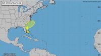
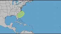
The National Hurricane Center (NHC) is closely monitoring the first potential tropical disturbance of the 2025 Atlantic hurricane season, located off Florida's eastern coast. As of early June 3, 2025, this non-tropical area of low pressure is forecast to develop near or just offshore of the southeastern U.S. coast within the next few days, marking the first official area of interest for the season that began on June 1.
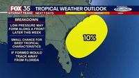
Although the chance of this system developing into a tropical or subtropical storm remains low—estimated at about 10% over the next seven days—the NHC is keeping a vigilant eye on its progress. The system is expected to move northeastward at speeds between 10 to 15 miles per hour, potentially gaining some subtropical or tropical characteristics by midweek if it stays offshore.
Local meteorologists advise that even if the disturbance does not reach tropical storm status, it could still bring gusty onshore winds ranging from 25 to 35 miles per hour along Florida’s east coast, stretching from Jacksonville down to the Space Coast. These conditions may produce rougher surf and heightened thunderstorm activity between June 5 and June 6, 2025, affecting coastal communities and beachgoers alike.
Recent weather patterns have already caused travel disruptions in Miami and Fort Lauderdale, with heavy rains and storms impacting flights and road conditions. A flood watch remains in effect for several South Florida counties, including Broward, Collier, Miami-Dade, and Monroe, as the region braces for multiple rounds of heavy rainfall. Some areas have already recorded localized rainfall amounts as high as six inches in a 24-hour period, underscoring the potential for flooding.
Adding to the complexity, Saharan dust is moving across the Atlantic and into Florida this week, which tends to suppress storm development by introducing dry air that inhibits tropical system formation. This natural phenomenon is expected to linger through Saturday, June 7, 2025, contributing to hazy skies across parts of Florida and the Caribbean.
NHC Director Michael Brennan highlighted that June is a typical month for storm formation near the U.S. coast, stating, “This is where we tend to see storms form in June, from the Gulf, across Florida, off the Southeast and mid-Atlantic coasts. So, it’s a great reminder that typically in June, those storms do tend to form pretty close to home, and people need to be ready and keep an eye out.”
Land interaction remains a significant factor limiting the system’s organization, as the disturbance is forecast to remain either over land or very close to the coast initially. This proximity to land reduces the likelihood of rapid development, as friction and lack of open warm water hinder storm strengthening.
Beyond this initial system, meteorologists are also watching a tropical wave in the eastern Atlantic moving westward at 11 miles per hour, which could influence future tropical activity later in the season.
Experts from the National Oceanic and Atmospheric Administration (NOAA) and Colorado State University (CSU) forecast an above-average 2025 Atlantic hurricane season, fueled by warm ocean temperatures and favorable atmospheric conditions. NOAA predicts between 13 and 19 named storms, including 6 to 10 hurricanes, with 3 to 5 reaching major hurricane status (Category 3 or higher). CSU’s forecast is slightly more active, anticipating 17 named storms, 9 hurricanes, and 4 major hurricanes.
These projections exceed the average Atlantic hurricane season, which typically sees 14 named storms, 7 hurricanes, and 3 major hurricanes. The expectation for heightened activity stems largely from the Neutral Phase of the El Niño-Southern Oscillation (ENSO), which reduces wind shear in the Atlantic basin, allowing storms to form and intensify more easily. Additionally, a more active Western African Monsoon contributes to the increased potential for tropical cyclone development.
Colorado State University also estimates the probability of a major hurricane making landfall in various regions: a 51% chance for the entire U.S. coastline (above the historical average of 43%), 26% for the U.S. East Coast including Florida (average 21%), 33% for the Gulf Coast (average 27%), and 56% for the Caribbean (average 47%). These elevated probabilities underscore the importance of preparedness as the season unfolds.
Residents along Florida’s coast are urged to prepare early, even with the season just underway. Recommended measures include knowing evacuation zones and routes, staying informed through weather alerts and trusted news sources, planning for vulnerable family members and pets, and safeguarding important documents and supplies. Meteorologists emphasize that it’s never too soon to assemble emergency kits with essentials like food, water, medications, and communication devices.
The Atlantic hurricane season officially runs from June 1 through November 30, with peak activity typically occurring around September 10. While early-season storms like this disturbance near Florida often form close to the U.S. coast, the most active period usually spans mid-August to mid-October, when tropical waves emerge from the African coast and traverse the Atlantic.
As the season progresses, the National Hurricane Center and local weather teams will continue providing updates and advisories to keep residents informed and safe. The FOX 35 Storm Team and other regional meteorologists are dedicated to delivering timely forecasts and guidance, urging everyone to stay vigilant and prepared.
Whether this initial disturbance develops into a named storm or not, it serves as a timely reminder that hurricane season is here, and the time to prepare is now.