On June 5, 2025, a powerful and dangerous weather event unfolded across Lubbock, Texas, and surrounding areas, marked by multiple tornadoes, severe storms, and widespread damage. The National Weather Service (NWS) in Lubbock issued a Particularly Dangerous Situation (PDS) tornado warning as a series of severe thunderstorms swept through West Texas and parts of eastern New Mexico, impacting over 859,000 residents across dozens of counties.
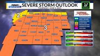
The day began with forecasters from the NWS Storm Prediction Center highlighting an enhanced risk zone for severe thunderstorms across the South Plains, including Lubbock and neighboring cities such as Shallowater, New Deal, and Smyer. The conditions were ripe for tornado development, with deep moisture, atmospheric instability, and favorable wind shear creating a "focused corridor for tornadoes," some potentially strong. This region, part of the infamous Tornado Alley, has a long history of violent tornadoes, including the catastrophic F5 tornado that devastated Lubbock in May 1970.
KLBK Chief Meteorologist Jacob Riley warned residents late Thursday afternoon about the threat of severe storms expected to develop across the viewing area, lasting into the overnight hours. A Tornado Watch was issued for every county within the KLBK viewing area through 10 PM CDT, signaling the possibility of damaging wind gusts up to 80 mph, large hail with diameters as large as 5 inches (DVD-sized), isolated strong tornadoes, and flash flooding with localized rainfall totals between 2 and 4 inches. Riley advised caution as storms began to develop over western areas around early afternoon, then spread east-southeast, with some areas potentially seeing no rainfall or severe weather at all.
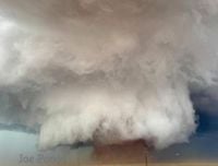
As the afternoon progressed, radar and spotter reports confirmed multiple tornado touchdowns. At 5:13 p.m. CDT, a tornado was confirmed near Maple, Texas, moving east at 20 mph, producing damaging winds and three-inch hail. Shortly afterward, a large and extremely dangerous tornado was confirmed near Morton, Texas, moving east at 30 mph, classified as a Particularly Dangerous Situation. This tornado caused significant concern as it moved through rural areas in northeastern Cochran and northwestern Hockley counties.
Throughout the evening, tornado warnings were continuously updated and extended. A particularly alarming development occurred near Reese Center, west of Lubbock, where twin tornadoes were observed on the ground around 7:22 p.m. CDT. These tornadoes moved southeast at speeds ranging from 10 to 45 mph and were accompanied by softball-sized hail and damaging winds. The West Texas Mesonet Station at Smyer recorded wind gusts reaching 109 mph during this time, underscoring the severity of the storms.
The City of Lubbock activated its Outdoor Warning System, urging residents to seek immediate shelter. Liberty High School opened its gymnasiums and storm shelters to provide refuge for those without safe shelter. Local officials emphasized the need to take cover on the lowest floor of sturdy buildings and avoid windows, heeding expert advice to protect oneself from flying debris.
Severe weather caused widespread damage. Reports came in of broken windows and skylights shattered by hail across parts of Lubbock, with flooding compounding the hazards. Wind damage was notable in west Lubbock and Lubbock County, including damage to the West Carlisle Volunteer Fire Department's headquarters. Crews from the department were dispatched to assist with search and rescue efforts in Hockley County, where at least one person was reported injured and transported to the hospital. Fortunately, as of late Thursday night, no fatalities were reported.
Infrastructure suffered as well. Tornadoes and high winds snapped utility poles, leading to thousands of residents in West Texas and Lubbock losing power. Xcel Energy and Lubbock Power & Light worked through the night to restore electricity. Additionally, damage to a water substation in Levelland prompted officials to call for immediate water conservation measures.
The National Weather Service canceled all tornado warnings for Lubbock County and other West Texas counties by 8:34 p.m. CDT, but severe thunderstorm warnings remained in effect, cautioning residents about ongoing hazards such as large hail and damaging winds. A severe thunderstorm capable of producing a tornado was reported over downtown Lubbock around 8:25 p.m., moving southeast at 10 mph, with wind gusts recorded at 71 mph and tennis ball-sized hail.
Storm chaser Reed Timmer, on the ground in Lubbock during the storms, witnessed fierce winds that brought down power lines and trees just feet ahead of his vehicle, capturing the intense and dangerous conditions firsthand. Experts like meteorologist Matthew Cappucci urged residents to take shelter immediately and stay away from windows, emphasizing the life-threatening nature of the storms.
As of 10:53 p.m. CDT, a few severe storms persisted with primary risks of large hail and damaging winds, but the immediate threat of tornadoes had diminished. The storms left behind a trail of destruction but also demonstrated the effectiveness of early warnings and community preparedness in preventing loss of life.
Looking ahead, the weather pattern remained active, with forecasters warning of another round of severe weather expected on June 6, 2025, prompting another First Alert Weather Day for the region. Residents were advised to stay weather aware and keep emergency plans ready as the South Plains prepared for continued volatile weather.
In total, 32 Texas counties and six New Mexico counties were placed under tornado watch on June 5, encompassing a vast area from Andrews to Yoakum in Texas and Chaves to Roosevelt in New Mexico. This extensive watch area underscored the widespread nature of the threat and the importance of vigilance across multiple communities.
West Texas and eastern New Mexico faced a harrowing day on June 5, 2025, as multiple tornadoes and severe storms tested the resilience of residents and emergency responders. Thanks to timely warnings, public cooperation, and the dedication of first responders, the region weathered a particularly dangerous situation with limited injuries and no reported fatalities, a testament to the progress made in severe weather preparedness and response.