On Monday, June 16, 2025, Minnesota faced a dramatic and dangerous weather event that swept across much of the state, bringing severe storms, multiple tornadoes, large hail, and damaging winds. The National Weather Service (NWS) issued a tornado watch for a vast region encompassing central Minnesota, including the Twin Cities metro area, and extending into western Wisconsin. This watch was active until 9 p.m. and covered numerous counties such as Aitkin, Anoka, Benton, Carlton, Carver, Cass, Crow Wing, Dakota, Douglas, Grant, Hennepin, Hubbard, Isanti, Itasca, Kanabec, Kandiyohi, McLeod, Meeker, Mille Lacs, Morrison, Otter Tail, Pine, Pope, Ramsey, Scott, Sherburne, Stearns, Todd, Wadena, Washington, and Wright.
The day began with an early round of rain crossing the state in the morning, which was followed by a second wave of storms arriving in the early afternoon. These storms quickly intensified, prompting a series of severe weather warnings and alerts. By mid-afternoon, a special weather statement was issued for the Minneapolis area, warning residents of strong winds, large hail, and heavy rain. The atmosphere was charged with heat and humidity, with temperatures reaching into the mid-80s and dew points in the mid-70s, creating the perfect conditions for severe thunderstorms and tornadoes.
According to meteorologist Sven Sundgaard from Bring Me The News, "While there was a lot of morning convection, it wasn't widespread enough to totally squash severe potential. There's a lot of low level shear and instability thanks to our highest dew points of the season so far and the area where storms are developing have reached the mid 80s with mid 70s dew points. Storms that develop could easily hold together and sweep through the metro late this afternoon and evening. Large hail and tornadoes are possible with initial cells." His assessment proved accurate as the storms evolved.
Throughout the afternoon and evening, multiple tornado warnings were issued across the state. At 2:30 p.m., a small tornado was confirmed on the ground near Vining in Otter Tail County, moving east at 25 mph. Tornado warnings followed for several counties, including Todd, Wadena, Stearns, Meeker, Wright, Aitkin, Pine, Carlton, Cass, Crow Wing, McLeod, Carver, and others. Notably, a tornado was reported near Bertha in Todd County around 5 p.m., and another was confirmed near Brainerd, moving northeast from Gull Lake with accompanying golf ball-sized hail. The NWS also reported tennis ball-sized hail and wind gusts reaching up to 70 mph in some areas.
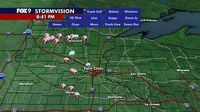
In the Twin Cities metro, severe storms arrived around mid-afternoon, bringing intense rain, lightning, and strong winds. A severe thunderstorm warning was extended for Carver, Dakota, Hennepin, and Scott Counties until 8:15 p.m. By 7:16 p.m., severe storms were hitting the southwest metro areas of Eden Prairie and Chaska, tracking toward Prior Lake. Baseball-sized hail and 60 mph wind gusts were reported south of the metro at 7:31 p.m. Additionally, a tornado warning was issued for Nicollet and North Mankato in southern Minnesota around 7 p.m., with a confirmed tornado moving southeast at 25 mph.
Despite the widespread warnings and the confirmed tornadoes, some counties reported no tornado touchdowns. For instance, the Stearns County Sheriff’s Office confirmed no tornado touchdowns during their roughly 30-minute warning period. Similarly, the Meeker County Sheriff's Office reported multiple rotation sightings and radar-indicated rotation but no confirmed touchdowns or damage. Nevertheless, several severe thunderstorm warnings were issued throughout central Minnesota, including areas like Kimball, Maple Lake, and Foley, where strong winds and quarter-size hail were observed.
Wind damage was also reported, with photos showing uprooted trees in St. Cloud, a city that faced strong winds during the storms. The severity of the weather was underscored by the National Weather Service's level 3 risk of severe weather for much of central and southern Minnesota, including the entire Twin Cities metro. This risk level indicated a significant threat of very large hail, wind gusts exceeding 60 mph, heavy downpours, and isolated tornadoes, with the main window for severe weather between 2 p.m. and 10 p.m., and the metro area likely experiencing the worst of it from 4 p.m. to 10 p.m.
As the evening progressed, the storms began to move out of Minnesota, with most weather activity clearing by 9 p.m. The forecast predicted that the skies would remain mostly cloudy but dry overnight, with temperatures dropping to the 60s. Tuesday was expected to bring calmer, less humid conditions with highs near 80 degrees, before rain chances returned later in the week.
The impact of the storms was significant, with 14 tornadoes reported across Minnesota on Monday alone. These tornadoes, along with the accompanying hail and winds, caused multiple reports of wind damage and widespread concern among residents. Emergency services and weather officials urged people to stay alert and take immediate protective actions when warnings were issued. The distinction between a tornado watch and a tornado warning was emphasized: a watch means hazardous weather is possible but uncertain in timing or location, while a warning means the event is occurring or imminent, requiring immediate action.
Images from various parts of Minnesota showed the dramatic effects of the storms, from hail-covered streets to downed trees and storm-churned skies. The Minnesota Department of Transportation cameras captured severe storms near Norwood, while local news outlets documented the unfolding situation with live updates and weather alerts.
This severe weather event served as a stark reminder of the volatile nature of Minnesota’s summer weather, where warm, humid conditions can quickly escalate into dangerous storms. Residents were advised to remain vigilant, especially during the peak hours of storm activity, and to have emergency plans in place. As the state recovers from Monday’s storms, attention will turn to the forecast for the rest of the week, which promises a brief respite before the return of heat, humidity, and scattered showers.