Residents of Minnesota are bracing for a potentially catastrophic weather event as severe storms are expected to sweep across the region on Monday afternoon and evening, April 28, 2025. Meteorologists are warning of a significant outbreak of severe weather that could bring tornadoes, large hail, and damaging winds to much of the state, particularly in the Twin Cities and surrounding areas.
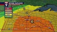
The National Weather Service (NWS) has issued a moderate risk (level 4 out of 5) for severe weather across southeast Minnesota, including Minneapolis and Rochester. This warning indicates that the conditions are ripe for dangerous storms capable of producing long-lived tornadoes, some of which could develop after dark, making them harder to detect and prepare for. According to NOAA's Storm Prediction Center (SPC), the threat of strong to intense tornadoes, very large hail, and damaging winds remains high.
As of Monday morning, April 28, a first round of thunderstorms has already passed through the area, with reports of heavy rain and small hail. However, meteorologists are closely monitoring the atmosphere for a second round of severe storms expected to develop between 1 p.m. and 3 p.m. in western Minnesota, which will then push eastward toward the Twin Cities.
Jim Cantore from The Weather Channel emphasized the urgency of the situation, stating, "Fast moving storms will evolve into the upper Mississippi Valley later today and tonight. This will be the main show." He noted that while there is a possibility of a squall line developing, isolated supercell storms could pose a greater tornado threat.
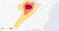
The Torcon Index, a measure of tornado potential, has placed the Twin Cities metro area at a 7 on a scale of 10, indicating a high likelihood of tornado activity. The SPC has warned that if the storms maintain a discrete mode, the potential for long-track tornadoes increases significantly.
In terms of timing, the most critical period for severe weather is expected to occur between 4 p.m. and 9 p.m. on Monday. The NWS has advised residents to remain vigilant during this time, as storms could bring not only tornadoes but also large hail capable of causing significant damage. Reports of hail as large as quarters have been forecasted, alongside wind gusts exceeding 60 miles per hour.
As the storms approach, the NWS has issued a tornado watch for numerous counties across the region, including Brown, Chippewa, Cottonwood, Jackson, Kandiyohi, Lac qui Parle, Lincoln, Lyon, Martin, McLeod, Meeker, Murray, Nicollet, Nobles, Pipestone, Pope, Redwood, Renville, Rock, Sibley, Stearns, Stevens, Swift, Watonwan, and Yellow Medicine. This watch will remain in effect until 8 p.m. on Monday.
In preparation for the severe weather, school districts in Minneapolis and St. Paul have canceled after-school programs and activities, urging families to review their severe weather safety plans. The NWS has recommended that residents have multiple methods to receive weather alerts, such as weather radios and mobile notifications, and to know their safe places for shelter.
"If you don’t have adequate shelter where you live or work, have an idea in your mind where you should go before storms arrive," said NWS Meteorologist Tyler Hasenstein. The agency has also urged residents to secure outdoor furniture and clear debris from gutters to prevent flooding, as heavy rainfall is expected alongside the storms.
The severe weather threat is not confined to Minnesota alone, as the National Weather Service has indicated that storms will also affect parts of Iowa, Wisconsin, and even extend into the Upper Peninsula of Michigan. A major severe weather outbreak is forecast to stretch from Texas through the Plains and Midwest, raising concerns for widespread damaging winds and hail across a large area.
AccuWeather meteorologists have highlighted the potential for long-lived tornadoes, particularly those that develop later in the evening when visibility is reduced. Residents are advised to stay updated on weather conditions and to take all warnings seriously.
This severe weather event follows a trend of increasingly volatile weather patterns in Minnesota, where the state has seen a rise in severe storms outside the traditional tornado season. Last year, six tornadoes were confirmed across central and southern Minnesota, marking an uptick in severe weather activity that has scientists and meteorologists concerned.
As the day progresses, the NWS will continue to provide updates on the evolving situation, and residents are encouraged to remain alert and prepared for any potential emergencies. The storms are expected to shift eastward into states like Oklahoma and portions of the Ohio Valley as the weather front continues its path.
In summary, Monday, April 28, 2025, promises to be a day of significant weather challenges for Minnesota residents, with a high likelihood of severe storms, tornadoes, and damaging winds. As always, staying informed and prepared is crucial in facing the potential dangers that severe weather can bring.