After a weekend of record-breaking heat that left Minnesotans reaching for their fans rather than their sweaters, the state is bracing for a dramatic shift: a winter that, according to multiple forecasts, could be fiercely cold and stormy. The sudden swing in weather patterns—91 degrees in the Twin Cities on Saturday, October 4, 2025, followed by a cold front just a day later—has many residents wondering what’s in store for the months ahead.
AccuWeather released its winter outlook late last week, and the message is clear: Minnesota, along with much of the Midwest, should prepare for a frigid season. "Energy bills could run high as residents in more than a dozen states across the Plains and Midwest turn up the heat during what is likely to be a cold winter," AccuWeather warned in its recent report. The forecast paints a picture of a winter that will not only test thermostats but also wallets, as heating costs are expected to climb.
The timing of the cold is particularly notable. According to AccuWeather, the chill will settle in early in December 2025, catching many off guard after such an unseasonably warm autumn. However, the cold won’t be relentless—at least not at first. The forecast anticipates a brief respite in January, with a thaw that might tempt Minnesotans to believe spring is coming early. But don’t be fooled. By February, winter is expected to return with a vengeance, as frigid air expands across the central and eastern United States.
Bring Me The News meteorologist Sven Sundgaard is among those closely watching the evolving weather patterns. He recently highlighted a phenomenon in the Pacific Ocean—a so-called "heat blob"—that could have a profound impact on Minnesota’s winter. "One can imagine that come winter, this will open Minnesota up to frequent cold outbreaks. But that doesn’t mean the whole winter will be cold," Sundgaard wrote. He described the likely scenario as a "sloshing back and forth of cold and warm," meaning the state could see sharp swings in temperature rather than a steady deep freeze.
The last time Minnesota saw a combination of a quiet Atlantic hurricane season and a Pacific "heat blob" was during the winter of 2013-14, which many residents still remember as one of the most brutal in recent memory. That year, temperatures regularly plunged well below zero, and the state was blanketed in snow for months. If history is any guide, Minnesotans might want to dig out their heaviest coats and snow shovels sooner rather than later.
Speaking of snow, what can residents expect this year? The modern snowfall average in Minneapolis is 51.2 inches. AccuWeather predicts that this winter will see normal snowfall, offering an estimate of 48 to 55 inches for the Twin Cities. That’s not a record, but it’s certainly enough to keep snowplows busy and sledding hills packed. AccuWeather meteorologist Paul Pastelok added, "It can be an intense stormy winter for areas of the country, particularly across the Midwest, Great Lakes, Ohio Valley, Northeast and parts of the mid-Atlantic." This suggests that while snowfall totals may be typical, the storms themselves could be more intense than usual.
For now, however, there’s no snow in the immediate forecast. That’s a relief for many, especially considering that just five years ago, the Twin Cities were hit with a surprise snowstorm that dumped eight inches on October 20. As of October 5, 2025, the National Oceanic and Atmospheric Administration (NOAA) is predicting normal temperatures and precipitation for Minnesota through January 2026. So while the long-term outlook is daunting, the short-term forecast offers a bit of breathing room.
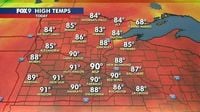
This all comes on the heels of a remarkable weather event: record-setting heat across the state. On October 4, the Twin Cities metro area soared to 91 degrees, smashing the previous record of 89. And it wasn’t just the metro. Hibbing reached 83 degrees, Brainerd and Rochester both hit 86, and Duluth topped out at 84—all new records for the day, according to FOX 9. Winds from the south kept temperatures high throughout the weekend, with the heat expected to linger into Sunday, October 5, when a high of 78 degrees was forecasted. But, as is often the case in Minnesota, change was already on the horizon.
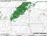
By Sunday evening, the weather had shifted dramatically. A cold front swept through the state, ending the streak of unseasonable warmth and bringing precipitation from 7 a.m. to midnight, according to NOAA data shared by MPR News. The return to more typical seasonal weather was swift, with forecasters predicting a crisp start to the week of October 6 and seasonal conditions to persist for the rest of the week. It’s a vivid reminder of how quickly Minnesota’s weather can turn on a dime.
So, what’s driving these wild swings? Meteorologists point to a combination of large-scale climate patterns and local factors. The Pacific "heat blob"—a mass of unusually warm water—has the potential to disrupt the jet stream, allowing cold Arctic air to plunge southward more frequently. At the same time, the lack of a strong Arctic dry air mass could mean more opportunities for snow, as moist air collides with cold fronts over the Midwest. It’s a recipe for a winter that could be both colder and stormier than average, even if snowfall totals remain within the normal range.
Of course, long-range forecasts are always subject to change, and Minnesotans know better than to take any prediction as gospel. Still, the consensus among experts is clear: this winter could be one for the record books. With energy bills likely to rise and the potential for intense storms on the horizon, residents are advised to prepare now—whether that means scheduling a furnace tune-up, stocking up on salt, or simply bracing themselves for whatever Mother Nature has in store.
As the state transitions from record heat to the threat of a deep freeze, one thing is certain: Minnesota’s weather never fails to keep people guessing. And as meteorologists continue to monitor the evolving patterns, the only real certainty is that change is always just around the corner.