As severe weather awareness week unfolds, regions across the Midwest brace for intense and potentially dangerous storms today, March 19, 2025.
Forecasts indicate that scattered severe thunderstorms could produce damaging winds, large hail, and a high likelihood of tornadoes, particularly impacting areas from Illinois through Indiana. While the recent storms that swept the nation claimed more than 40 lives, today’s events hold their own risks that are noteworthy.
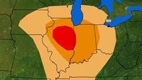
The National Oceanic and Atmospheric Administration's (NOAA) Storm Prediction Center has classified the risk for severe storms as a level 3 out of 5 in areas including Peoria and Champaign, Illinois, highlighting the potential for strong tornadoes, EF2 or greater. Meteorologists warn that tornadoes in this bracket have the capacity to cause significant destruction.
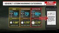
Severe thunderstorm warnings commonly fit into three categories: BASE, Considerable, and Destructive. The BASE warning generally covers winds between 58 and 69 miles per hour and quarter-sized hail. Considerable severe thunderstorm warnings escalate to winds exceeding 70 miles per hour or hail nearing two inches, signaling broader threats to populated areas. Destructive warnings, often signaling the utmost danger, involve winds above 80 miles per hour, potentially obliterating roofs and windows and causing widespread havoc.
Today's storm developments are expected to intensify by mid-afternoon and could last into the early evening. For those living in affected regions, including parts of northern Indiana and southern Michigan, preparedness is crucial. Past storms have demonstrated the devastating consequences of underestimating severe weather. As noted by the National Weather Service, “It really only takes one instance of severe weather to cause some real damage.”
In addition to the severe thunderstorms, the Midwest faces further complications. Blizzard conditions are also forecasted for northern Kansas through southern Minnesota, with snowfall rates reaching up to two inches per hour and winds surpassing 50 mph, leading to blizzard-like conditions and hazardous travel. The heavier snowfall could result in visibility drops and dangerous roads.
Earlier warnings focused on the aftermath of last week’s intense storms, which resulted in fatalities linked to tornadoes, dust storms, and wildfire incidents. People are urged to heed caution as forecasters anticipate prone weather patterns that place large areas at risk.
Additionally, an “enhanced risk” warning has been issued by the National Weather Service for areas in the Middle Mississippi and Ohio Valleys and throughout the Upper Great Lakes, heightening concerns for additional tornado occurrences as the atmospheric conditions raise instability levels.
Travel limits are recommended amidst these volatile forecasts, especially for the Central Plains to Upper Great Lakes, where blizzard conditions may arise. And as spring peaks, experts indicate that simply preparing for severe storms could mean the difference between safety and disaster.
Alerts from meteorological services emphasize creating a survival kit if travel is necessary. The days ahead will test how well individuals and communities have readied themselves for such unpredictable weather changes.
It's easy to overlook the importance of severe thunderstorm preparedness in everyday life until faced with the reality of nature’s unpredictability. As we witness changing weather patterns, understanding storm alerts and monitoring forecasts can help navigate these troubled waters.
In summary, as crucial threats loom, the advice from Weather Channel representatives resonates strongly: be informed, be prepared, and stay safe.