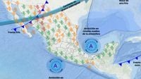
Mexico is preparing for another cold front, as the spring season approaches yet strong weather phenomena linger over several regions of the country. The latest forecasts from the Servicio Meteorológico Nacional (SMN) indicate significant changes are on the horizon with the introduction of cold front number 36 set to impact the northwest region starting tonight.
On March 17, 2025, residents of the northwest and northern parts of Mexico can expect gusty winds ranging from 30 to 50 km/h, with strengths peaking at up to 80 km/h, particularly affecting states such as Chihuahua, Coahuila, and Durango. These winds are anticipated to create dust storms and reduce visibility, increasing safety concerns for those on the roads.
The cold front, which is moving over the country, will interact with both polar and subtropical jet streams, generating strong weather patterns. Previous cold front number 35, which is currently situated over the Caribbean Sea, has already ceased to affect Mexico directly. Nonetheless, the cold air mass associated with this system will continue to produce weather effects, particularly impacting the southeast of the country and the Yucatán Peninsula. It is expected to cause heavy rain, with projections indicating 25 to 50 mm of rainfall across Chiapas on the same day.
Regarding the climate conditions for Nuevo León, the forecast suggests wind speeds of 20 to 30 km/h with gusts reaching 50 to 70 km/h. Temperatures across this state are expected to remain unseasonably high for this time of year, staying above 30 degrees Celsius with minimums around 14 degrees.
Following the passage of this front, strong winds are projected to continue throughout March 19, resulting from the prevalence of atmospheric disturbances. This pattern of warm dan chilly air masses will signal fluctuative temperatures across the northwest, northeast, and central regions of the country.
According to the SMN report, there will be massive variations across Mexico's territories. While the northwest braces for the chilly air from cold front number 36, maximum temperatures of 40 to 45 °C are anticipated in states like Sonora, Sinaloa, Guerrero, and Oaxaca. This discrepancy highlights the unpredictable nature of seasonal transitions, stirring public wariness about the advent of potentially hazardous weather.
The report also specifies, on March 17, minimum temperatures between -5 and 0 °C may occur, particularly affecting mountainous regions across the State of Mexico, Hidalgo, Tlaxcala, and Puebla. These nighttime freezes will pose risks to crops and residents alike.
Overall, the progression through March is forecasted to be turbulent. The impending 'Norte' event initiated by the weather systems means winds strong enough to create poor visibility and even increase the risk of wildfires due to dry conditions elsewhere.
The SMN has urged citizens to remain vigilant, continuously monitoring updates and reacting according to guidelines established by local civil protection agencies. Preparations for flash floods and potential wind damage caused by falling trees or downed power lines should be prioritized as the situation develops.
With reports coming from various regions, it’s clear the Mexican populace must navigate through this mixed bag of weather, balancing between preparing for severe conditions and enjoying the warmth of early spring days. The coming weeks will be especially telling as the country balances the remnants of winter’s chill against the forward push of warmer weather.