Japan is bracing for a significant weather event as a powerful storm system, referred to as the "May Storm," sweeps across the archipelago from the night of May 9 to May 10, 2025. The Japan Meteorological Agency has issued warnings for heavy rainfall and strong winds, raising concerns about potential flooding and other weather-related hazards.
In Nagasaki's Goto City, localized heavy rain caused roads to flood around 2 PM, with water levels rising to ankle-deep for pedestrians. Reports from Fukue Airport indicated a record-breaking rainfall of 62 mm in just one hour, marking the highest rainfall recorded for May. Alongside this, wind gusts reached up to 20.6 meters per second, prompting some students to abandon their umbrellas in favor of simply braving the downpour.
By 4 PM in Shimonoseki, Yamaguchi Prefecture, large raindrops pelted car windshields, making it difficult for drivers to exit their vehicles due to the intensity of the storm. The storm's impact was felt across various regions, with the historic Karatsu Castle in Saga Prefecture partially obscured by the heavy rain. As the sea roiled with whitecaps, residents prepared for the storm's effects.
Before 9 AM in Kitakyushu, people were seen walking with their umbrellas tilted forward, attempting to shield themselves from the fierce winds. The maximum instantaneous wind speed recorded in Yahata, Kitakyushu, was 15.2 meters per second around 9:30 AM, illustrating the storm's ferocity.
As the storm progresses, the Kanto region is also on alert for heavy rain warnings expected to continue into May 10. Tokyo's Ueno district, typically bustling with activity, is facing uncertainty as the annual Shitaya Shrine Grand Festival approaches this weekend. Known for its lively atmosphere, the festival has raised concerns among local businesses about the weather's potential to deter visitors. One local restaurant owner expressed hope that the rain would not deter crowds, stating, "We’re counting on people to come out despite the forecast. We just hope the weather prediction turns out to be wrong!"
The Japan Meteorological Agency has issued a heavy rain warning for Sasebo City, excluding the Uku area, at 6:12 PM on May 9. Residents are advised to remain vigilant for flooding in low-lying areas, particularly in the northern regions, where the risk of inundation persists until late evening.
According to forecasts from the Nagasaki Local Meteorological Observatory, the expected rainfall from 6 PM on May 9 to 6 PM on May 10 is projected to be 40 mm per hour and 60 mm over 24 hours. This includes warnings for sediment disasters and flooding, particularly in Sasebo City.
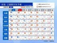
As the storm continues, the weather outlook for the following week indicates a shift towards warmer temperatures. Starting on May 10, the regions from Kyushu to Kanto are expected to experience summer-like conditions, with temperatures surpassing 25°C. The day after the storm, May 11, may bring sunny spells across the Pacific side of western and eastern Japan, although clouds are still anticipated.
However, the weather forecast is not entirely positive, as Okinawa is expected to remain cloudy or rainy until May 14. The Meteorological Agency has cautioned that from around May 14, temperatures could reach levels not seen in a decade for this time of year, raising concerns about heat-related illnesses.
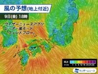
The warnings extend to the coastal areas of Fukuoka, Saga, and Nagasaki, where gale warnings have been issued. Residents are urged to be cautious of flying debris as the low-pressure system moves eastward, intensifying wind conditions. Reports indicate that areas like the northern coast of Kyushu and the Bungo Channel could see average winds of 15-20 m/s, with gusts exceeding 30 m/s.
In light of these conditions, the Meteorological Agency has provided detailed rainfall forecasts for various prefectures. For instance, Fukuoka and Saga Prefectures are expected to see 40 mm of rain per hour, with total rainfall reaching 100 mm over 24 hours. In Nagasaki, the forecast calls for 60 mm per hour and up to 120 mm over the same period.
As the storm unfolds, the public is advised to stay updated with the latest weather alerts and to prepare for possible disruptions to transportation and daily activities. Local authorities are on high alert, and emergency services are prepared to respond to any incidents arising from the severe weather.
With the May Storm making its presence felt across Japan, the combination of heavy rain and strong winds poses a significant risk to residents. The upcoming days will be crucial as communities brace for the storm's impact while also looking ahead to the warmer weather that follows.