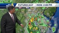
As the remnants of Tropical Storm Chantal sweep through Maryland, residents of the Baltimore region are bracing for a challenging week marked by intense heat, heavy rainfall, and the looming threat of severe thunderstorms. The National Weather Service (NWS) has issued a Flood Watch effective from 10 a.m. to 6 p.m. on July 8, 2025, warning of potential flash flooding along the Chesapeake Bay, particularly impacting areas on the Western Shore where localized rainfall could reach up to five inches.
Early reports from the National Weather Service Baltimore MD/Washington DC highlight the severity of the system, noting that "This system has a history of producing much more than that in NC and will be accompanied by an anomalously moist atmosphere with deep warm cloud layers that will support very efficient rain." This combination of moisture and cloud structure is driving the intensity of the rain, which is expected to weaken and cross through Maryland throughout the day.
The weather pattern is anything but simple. While the remnants of Chantal bring heavy rain concentrated mostly on the Eastern Shore, the Western Shore is not spared, with scattered thunderstorms anticipated primarily in the afternoon. Temperatures will remain uncomfortably high with heat indices reaching the upper 90s near and east of I-95, and lower 90s to the west. This oppressive heat, combined with the moisture, creates an environment ripe for severe weather.
In fact, the National Weather Service has cautioned about the increased coverage of showers and thunderstorms on the afternoon and evening of July 8, 2025. The hot and humid air mass could trigger a few severe thunderstorms capable of producing damaging winds, although the risk is somewhat tempered by modest atmospheric shear and moist profiles.
Adding to the urgency, Baltimore City’s health department has declared a Code Red extreme heat alert for the day. Thirteen cooling centers have been activated to provide relief, and city employees are operating under "enhanced safety protocols." Anne Arundel County and parts of Harford and Baltimore counties are also under a heat advisory from 1 p.m. to 7 p.m., with triple-digit heat index values forecasted. BWI Marshall Airport is expected to see a high of 92 degrees Fahrenheit with heat indices soaring up to 106 degrees.
Storm activity is expected to begin in the late afternoon, with showers and possibly thunderstorms developing as the day progresses. Temperatures will cool somewhat overnight, dropping to lows around 72 degrees Fahrenheit as rain continues. Wednesday, July 9, 2025, will see partly sunny conditions with highs near 91 degrees and a 50% chance of rain throughout the day and evening. The unsettled weather pattern will persist into Thursday and Friday, with showers and thunderstorms likely through the day and night, accompanied by mostly cloudy skies and slightly cooler highs in the upper 80s to mid-80s.
The threat of severe thunderstorms is significant enough that WJZ has issued First Alert Weather Days for both Tuesday and Wednesday. Overnight into early Tuesday, the region will remain warm and humid, with temperatures lingering in the 70s and patchy fog developing by morning. By Tuesday afternoon, the surge of heat and humidity will set the stage for scattered thunderstorms, some potentially severe. Damaging wind gusts, torrential rainfall, and frequent lightning are all possible, especially after 2 p.m. through the early evening hours.
Storms are expected to taper off Tuesday night, but the warm, muggy conditions will persist with patchy fog and overnight lows in the low to mid 70s. Another round of storms is anticipated on Wednesday afternoon and evening as a slow-moving cold front stalls across the region. This front is forecasted to linger through the weekend, keeping the area locked into a pattern of daily thunderstorm chances, primarily during the afternoon and evening.
For mariners, the remnants of Chantal are disrupting typical summer sailing conditions. The National Weather Service has issued marginal Small Craft Advisory conditions on the middle bay waters through mid-morning Tuesday, with the potential for heavy rain and thunderstorms later in the day. Coastal flooding has already been reported in Annapolis, caused by south-to-southeast winds pushing water levels higher than usual. Fortunately, as the remnants of Chantal pass, water levels are expected to gradually recede through midweek, reducing further flooding threats for now.
Residents are advised to stay vigilant and prepared as this volatile weather system unfolds. The combination of extreme heat, heavy rainfall, and the potential for severe storms creates a complex and hazardous environment. Outdoor plans should be flexible, and it is crucial to heed warnings from local authorities and weather services.
While mornings and early afternoons may offer some respite with mostly dry conditions and temperatures in the upper 80s to near 90 degrees, the afternoons and evenings will be dominated by storm activity. Flash flooding remains a concern, especially in areas prone to repeated heavy rainfall. The National Weather Service underscores the need for caution, noting that "shower and thunderstorm coverage will be much greater Tuesday afternoon and evening," setting the stage for a possibly stormy week ahead.
In summary, Maryland faces a challenging weather pattern this week as the remnants of Chantal bring heavy rain, heat, and severe thunderstorms. The National Weather Service, local health departments, and media outlets are all emphasizing the importance of preparedness and awareness as residents navigate this potentially hazardous period.


