As Manitobans welcome the arrival of spring, they are now facing what could be the biggest winter storm of the year, with snowfall warnings issued across the province. Environment and Climate Change Canada has alerted residents that a low-pressure system moving eastward from Alberta will bring significant snowfall, with totals expected to reach between 15 to 25 centimeters in Winnipeg and surrounding areas by late Friday, March 28, 2025.
According to David Phillips, a senior climatologist with Environment Canada, the snow expected over the next 24 hours could surpass what has already fallen throughout the winter. "The snow in spring is always more moist," he explained during an interview on 680 CJOB’s The Jim Toth Show. "It’s not the dry snow of January or February, and it’s got more moisture associated with it — and when you look at the drought situation, that’s very critical right now." This spring snowfall is not only a nuisance but could also mitigate potential droughts later in the summer.
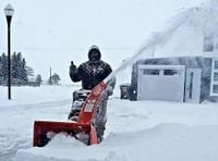
Initially, forecasts suggested that Winnipeg would be spared from significant snowfall, but as the storm approached, the city was placed under a snowfall warning. The City of Winnipeg has stated that its crews are ready to respond to the snowfall, monitoring conditions closely and prepared to apply sand and/or salt to roads. Currently, there are no winter parking bans in effect.
The snowfall is expected to begin Thursday afternoon, March 27, 2025, and will first impact areas east of Brandon, including Winnipeg and regions north of Steinbach. Light to moderate accumulation is anticipated throughout the day, with conditions worsening by Friday morning. Heavy snow is forecast to continue throughout the day, tapering off by Friday evening.
Environment Canada has warned that visibility may drop significantly due to heavy snow and localized blowing snow, especially in open areas. Travel is expected to become hazardous starting Thursday night, with highways and urban routes likely to be affected. In its official alert, Environment Canada advised residents to prepare for rapidly changing road and weather conditions and to check updated forecasts and highway advisories before traveling. "Snowfall warnings are issued when significant snowfall is expected," the agency noted in its bulletin.
Brad Vrolijk, a lead forecaster with Environment and Climate Change Canada, highlighted the severity of the storm, stating, "It will be an abrupt return to winter across the region." He indicated that snowfall rates could reach up to four to five centimeters per hour at times on Friday morning, creating nearly whiteout conditions. Vrolijk also pointed out that the initial snowfall warning covered a wide area stretching across Alberta, Saskatchewan, and Manitoba, impacting various regions.
On Thursday evening, March 27, 2025, the snowfall warning was downgraded to a special weather statement in Winnipeg and some parts of southern Manitoba, as an intense band of snow passed through the city. While some areas saw just a centimeter or two of accumulation, others experienced nearly 10 centimeters. Snowfall warnings remain in effect for regions just north and east of Winnipeg, as well as for much of western Manitoba, the Interlake, and a swath of eastern Manitoba, including the Whiteshell region.
A developing low-pressure system in Montana is expected to bring heavy snow to parts of western and south-central Manitoba, with the heaviest snowfall anticipated starting Thursday evening and continuing into Friday morning before tapering off overnight. Generally, areas along the eastern slopes of Riding Mountain and Duck Mountain, as well as the Swan Hills, could see upwards of 20 centimeters by Friday evening. The Whiteshell region is also forecasted to be hit hard, with accumulations ranging from 25 to 35 centimeters.
As the winter storm takes hold, Manitobans will have to adjust to a significant drop in temperatures, with daytime highs expected to hover around –1 C to –6 C through the weekend of March 29-30, 2025. This is a stark contrast to the double-digit temperatures experienced earlier in the week. The normal high for this time of year is typically around 4 C. Vrolijk noted, "With that much fresh snow, it will limit how quickly we can warm up," suggesting that residents should brace for a chilly start to spring.
As the storm unfolds, it serves as a reminder of the unpredictable nature of spring weather in Manitoba. While the snow may cause short-term inconveniences, experts like Phillips emphasize its importance for replenishing moisture levels and potentially alleviating drought conditions later in the year. As the province prepares for the storm, residents are encouraged to stay informed about weather updates and to take necessary precautions when traveling.