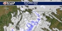
KAMLOOPS — On the first day of spring, Mother Nature seemed to ignore the calendar as a powerful late winter storm affected multiple regions in the Midwest.
In British Columbia, Environment Canada issued a special weather statement, which was quickly upgraded to a snowfall warning for the Coquihalla Highway between Hope and Merritt. Drivers were advised to brace for up to 30 cm of snow by Friday evening. "A Pacific frontal system will impact southern B.C. tonight through Friday," Environment Canada stated, predicting light to moderate snowfall that would intensify to heavier amounts throughout the day.
As the storm swept across the Midwest, a blizzard descended on Iowa, where various regions reported impressive snowfall totals. For instance, Lakota saw an astonishing 14.5 inches of snow, while Algona recorded 12.5 inches. Other areas, including Ledyard with 12 inches and Buffalo Center at 11 inches, also experienced significant snowfall. The blizzard hit on Wednesday, March 19, 2025, but Des Moines narrowly avoided the heavier totals, receiving only a trace of snow alongside some rain.
Alongside Iowa's snowfall data, the National Weather Service compiled totals for Wisconsin, where a late winter storm left most of the central part of the state blanketed in snow. Areas like Neillsville received the highest total with 10 inches, while places like Marshfield and Custer received around 7 inches. A representative from the National Weather Service in Green Bay remarked, "The snow likely won’t linger as above-freezing temperatures and sun are in the forecast for the next five days."
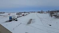
Moreover, the Nebraska storm brought similar blizzard conditions, with most areas north and west of Omaha getting between 6 to 12 inches of snow. Notably, Waco recorded a total of 12 inches, closely followed by Shelby with 10 inches, and York with 9.5 inches. The impact of the storm was felt by residents and prompted officials to issue warnings regarding travel. A local representative noted, "We know it was bad, though, and we know it's a lot better now" as conditions improved.
In addition to reports from the Midwest, a winter weather advisory was also in effect for Dodge, Fond du Lac, Ozaukee, Sheboygan, and Washington counties in Wisconsin as snowfall data was collected on the morning of March 20. Snowfall amounts varied; Cedar Grove reported 3 inches, while Random Lake had about 3.7 inches.
Meanwhile, in West Virginia, a rain transition was forecasted to yield light snow in mountainous regions. Reports indicated trace amounts were expected in the lowlands, while higher elevations could see up to 2 inches. Weather forecasts indicated highs would be around the 50s in the lowlands and mid-40s in more elevated areas.
As the storm passes, weather reports indicated potential improvements in conditions. For Nebraska, the high temperature is expected to rise to 55 degrees on Friday, March 21, and could reach 62 degrees on Saturday, March 22. Travel advisories have urged caution as icy conditions remained possible on Thursday morning.
The significant snowfall across different states serves as a reminder of the unpredictable nature of spring weather in the Midwest as regions shift from winter's grip to warmer weather. This storm demonstrates how climatological factors can bring dramatic weather changes within short periods, and while the snow may present hazards now, the coming days promise a brightening in conditions with warming temperatures.