Las Vegas is bracing for a significant weather shift this week, as forecasts indicate a departure from the unseasonably warm temperatures that have characterized the city in recent days. According to the National Weather Service (NWS), today and tomorrow will see above-average temperatures, reminiscent of the sunny 90-degree days enjoyed over the weekend. However, by the end of the week, a series of weather systems will converge, bringing much-needed moisture and a possible cool down.
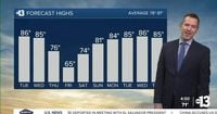
As of April 15, 2025, the weather pattern is set to change dramatically. Early this morning, showers accompanied by thunder were reported lifting north of Las Vegas, transitioning the city from its warm beginnings in the 60s and 70s to partly cloudy skies with southeast winds at 10-20 mph this afternoon, as highs are expected to reach the mid-80s.
Looking ahead to Wednesday, April 16, forecasters predict a breezy day with south winds blowing at 15-25 mph. The temperature will remain warm, with highs again in the mid-80s. However, the calm will be short-lived as a shortwave from western Canada is set to meet a cutoff low arriving near Point Conception on Thursday, April 17. This convergence is expected to gather moisture and create scattered showers and isolated thunderstorms, particularly across the Great Basin and Sierra regions.
"A single, closed low over the Great Basin and Mojave Desert" will take shape on Thursday and Friday, according to the NWS, which will likely spread precipitation further south into Las Vegas. This change signals an end to the recent streak of warm, clear days.
By Friday, April 18, temperatures could drop significantly, possibly by as much as 15 degrees below normal, with highs only reaching the mid-60s after starting the day in the low 50s. The chance of rain hovers between 30-50%, and thunderstorms are a distinct possibility. Snow could also make an appearance in the Sierra and Spring Mountains, with a 50% chance of four inches or more, a rarity for this time of year.
As the week progresses, the winds will be strongest on Wednesday and Thursday, but they are expected to lessen as the weekend approaches. By Saturday, April 19, the forecast looks more pleasant, albeit cooler than average for mid-April, with morning temperatures near 50 degrees giving way to afternoon highs in the low-to-mid 70s.
Looking ahead to Easter Sunday, April 20, temperatures will start chilly in the low 50s at sunrise but are expected to climb to the low 80s by the afternoon, with plenty of sunshine and some afternoon southwest breezes at 10-20 mph.
Beyond the weekend, the following week from April 21-27 is projected to bring highs back into the mid-80s, slightly above average for this time of year. The UV index is forecasted to be high from 11:00 a.m. to 3:00 p.m., indicating a risk of sunburn in as little as 30 minutes, while it will remain moderate earlier and later in the day.
Moreover, pollen levels are expected to range from medium-high to high over the next several days, with ragweed, olive, and grasses being the primary contributors. The air quality forecast for today indicates a "moderate" level, as ozone has accumulated in the warm atmosphere.
As the weather changes, the NWS urges residents and travelers to remain vigilant, especially in aviation. Attention should be paid to Harry Reid International Airport and surrounding areas, where varying winds and potential overnight virga could briefly disrupt the usual flow of air traffic. The NWS has issued a cautionary note regarding possible erratic and gusty winds during the evening, although they admit confidence in this forecast remains low.
Spotters in the area are encouraged to report any significant weather events or impacts as they unfold. This week’s weather serves as a reminder of the unpredictability of the desert climate, where residents must often prepare to adjust their plans and wardrobes in response to swift changes in conditions.
In summary, Las Vegas is poised for a dramatic weather transformation, moving from warm, sunny days to a cooler, wetter pattern. As the community prepares for this shift, the emphasis on staying informed and adaptable is paramount.