The National Weather Service’s Climate Prediction Center announced last week that the current La Niña weather conditions, which formed in January 2025, have dissipated. La Niña conditions are characterized by cooler surface water temperatures in the Pacific Ocean and stronger trade winds, typically leading to drier weather in the southern and southwestern United States. The dry fall and mild winter experienced this year are classic examples of La Niña’s influence. Alex Tardy, Warning Coordination Meteorologist in the San Diego NWS office, noted in his post, "The water year [Oct. 1, 2024 through Sept. 30, 2025] is about 50 percent of normal. It’s been really warm, much above normal in our mountains." The previous three-year La Niña from 2020 to 2022 brought severe drought conditions to the West, highlighting the potential impacts of these weather patterns.
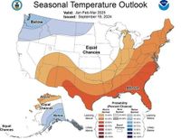
In contrast, El Niño conditions, which generally involve warmer surface water in the Pacific and weaker trade winds, can lead to increased precipitation in Southern California. However, the current neutral conditions are expected to persist through the summer and likely into the fall, according to the NWS. While the likelihood of El Niño conditions developing next winter is considered higher than that of La Niña, the probability of neutral conditions continuing remains the most significant of the three scenarios. Meteorologists caution that spring forecasts are notoriously less reliable, making it challenging to predict long-term weather patterns.
Emily Becker, writing for the National Oceanic and Atmospheric Administration’s blog, explained, "When neither El Niño nor La Niña are in effect, global seasonal conditions are less predictable." She added, "As spring turns to summer, our crystal ball should become clearer. For now, we’ll bid La Niña adieu and bide our time in neutral." This uncertainty underscores the difficulties faced by meteorologists in providing accurate forecasts during neutral conditions.
In Jacksonville, Florida, NOAA has officially declared the weak La Niña that lasted just a few months as over. This La Niña, although not particularly strong, had notable impacts across the continental U.S., including significant temperature fluctuations. Jacksonville experienced 18 freezes this winter, marking the most freezes since the 2010-2011 season, and a winter storm in mid to late January brought snow and ice to parts of North Florida and the Panhandle. The forecast for the upcoming summer indicates a neutral ENSO (El Niño-Southern Oscillation), which suggests that the Atlantic hurricane season may be “somewhat” above average.
As of now, there have been over 5,000 severe storm events reported this year, including tornadoes, damaging winds, and large hail. The forecast indicates that the Atlantic hurricane season will not be significantly affected by the neutral phase, allowing meteorologists to focus on other weather patterns.
Meanwhile, in Texas, the summer of 2025 is anticipated to bring above-average temperatures and below-normal rainfall, according to the Old Farmer’s Almanac. The report highlights that Texas, along with 30 other regions in the U.S., will experience “calurosas” and “secas” conditions, with temperatures potentially reaching up to 2 °C above normal, especially in July and August. Although June is expected to remain close to average, the subsequent months are likely to intensify heat, exacerbating the drought situation affecting more than 80% of Texas.
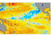
The La Niña phenomenon is characterized by a cooling of the sea surface in the central and eastern equatorial Pacific. The NOAA notes that severe weather events, such as large hail and tornadoes, are more common in the central and southern U.S. during the spring when La Niña is active. The recent La Niña appeared in December 2024 with minimal intensity and dissipated shortly thereafter. However, its exit does not signify a significant change in weather patterns, aside from a potential decrease in severe storms.
In 2024, Texas experienced its hottest year on record, with El Paso surpassing monthly temperature records in June and October. The last day with temperatures near 38 °C occurred in September 2024, a notable anomaly. This April, some areas of Texas approached 38 °C, nearly six weeks earlier than the historical average for such temperatures, which typically occurs between late May and late June. The National Weather Service (NWS) does not expect improvements in temperature or precipitation, anticipating a continuation of high temperatures and a lack of rainfall.
In Mexico, the transition from La Niña to a Neutral phase is expected to impact rainfall and temperatures throughout the summer of 2025. On April 10, 2025, the Climate Prediction Center reported that La Niña had ended due to a slow increase in Pacific surface temperatures, marking the beginning of the Neutral phase. This phase is characterized by temperature anomalies between -0.5 and +0.5 °C and is associated with significant changes and uncertainties in weather patterns.
The International Research Institute for Climate and Society (IRI) indicates a 100% probability of the Neutral phase persisting this spring, with a 60-80% chance extending through the summer and a 40-60% probability into autumn. While the likelihood of La Niña returning increases from 10% in May-June to nearly 40% in autumn, El Niño conditions are deemed unlikely, with less than a 20% probability.
This April has already seen extreme temperature fluctuations, with highs nearing 50 °C followed by a cold snap that brought record lows of -7 °C in the Altiplano regions of Veracruz and Puebla. As May approaches, rainfall is expected to increase in the central-eastern regions of Mexico, influenced by cold fronts and other climatic factors. The forecast suggests that while the central-southern areas may experience regular rainfall, the northwest and southeast regions could see below-average precipitation.
Looking ahead, the hurricane season in the Atlantic basin is predicted to be more active than usual, with the University of Colorado forecasting 17 named storms, 9 hurricanes of categories 1-2, and 4 major hurricanes of categories 3, 4, and 5. The probability of direct impacts from cyclones on the Caribbean and Gulf of Mexico coasts is estimated at 84% for any cyclone, 53% for hurricanes, and 23% for major hurricanes.
As the weather patterns continue to evolve, residents across the affected regions are urged to stay informed about changing conditions and prepare for potential impacts from severe weather events.