Today, Iowa is bracing for a dramatic shift in weather as the Midwest faces yet another strong storm system that will bring significant winter conditions and high winds across the state. On March 19, 2025, blizzard warnings have been placed for northwest Iowa, forecasting potentially dangerous conditions with temperatures plummeting and wind gusts reaching as high as 65 miles per hour.
Earlier in the day, Iowans enjoyed mild weather, with temperatures nearing 80 degrees Fahrenheit in places like Ottumwa. However, that warmth will not last long. Forecasters anticipate a considerable drop in temperature as a cold front moves in throughout the day. By Wednesday afternoon and into the evening, people will need to don their winter coats and snow boots once again. Temperatures will be markedly lower, likely falling into the mid-20s by Thursday morning.
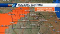
The National Weather Service's alerts indicate that the blizzard warning for northwest Iowa will be in effect from 5 a.m. to 10 p.m. on March 19. Areas affected include Fort Dodge, Carroll, Mason City, and the surrounding regions, where dangerous whiteout conditions with reduced visibility will occur. The rapidly changing weather will lead to challenging travel conditions with drifting snow and strong wind.
“A Blizzard Warning will be in effect for northwest Iowa with wind gusts up to 65 mph causing significant blowing and drifting snow leading to whiteout conditions at times,” the forecast highlights. Residents in these areas have been advised to avoid unnecessary travel if possible.
In addition to the blizzard warning, much of central and western Iowa is under a high wind warning from 7 a.m. to 7 p.m. Widespread wind gusts reaching 65 mph in these regions pose risks not only to transportation but also to tree limbs and power lines. As these severe patterns continue throughout the day, residents can expect the increased potential for power outages due to downed lines caused by high winds.
The weather forecast indicates that the considerable moisture accompanying this storm will mainly fall as snow in the aforementioned areas from sunrise through midday Wednesday, contributing to several inches of snow accumulation. However, as the storm system moves southeast, snowfall amounts will drop significantly within a relatively small area. For instance, residents in Des Moines can expect little to no accumulation, making it a sharp contrast to the snowfall anticipated northwest of their location.
“Several inches of snow are likely northwest of Carroll, Fort Dodge, and Mason City, with the snowfall totals dropping off sharply over a 20-mile distance southeast of these locations,” forecasts suggest.
As the day progresses, there's also a chance of strong storms impacting parts of southeastern and eastern Iowa, especially in the afternoon. There's potential for isolated large hail preceding the snowfall, particularly in these lower regions, which may add another layer of risk for those out in the elements.
Observing the rapidly changing weather, schools in western and northwestern Iowa have begun to announce delays and closures. School districts such as Audubon, Belmond-Klemme, CAL, Eagle Grove, and Newell-Fonda are among those that have canceled classes on Wednesday in anticipation of the hazardous conditions ahead. These school closures aim to safeguard students and staff from any potential dangers posed by the severe weather conditions. Families and students are urged to check their school’s specific website for the latest updates.
Despite the severe conditions forecasted for the northern part of the state, warmer weather remains in the forecast for central and southern Iowa where temperatures could still reach the 60s. Residents are reminded to prepare appropriately as Iowa's unpredictable weather approaches.
With the arrival of spring nearing, these weather conditions serve as a stark reminder of how quickly conditions can change, highlighting the importance of remaining informed and prepared for adverse weather scenarios. As Iowans experience this dramatic transition, they are encouraged to stay tuned to local news outlets for the latest updates and safety information.
As the state navigates through the impending storms, officials encourage everyone to exercise caution, heed safety warnings, and prepare for possible disruptions as winter returns momentarily to Iowa.