In a curious twist of fate, two locations in Inverkeithing, Scotland, have seemingly vanished from Google Maps, leaving local officials scratching their heads. Glebe Park and Glebe Terrace, which are situated in close proximity to each other, have been the subject of confusion following a series of mapping errors by the tech giant. Councillor David Barratt has been at the forefront of efforts to rectify this issue, expressing frustration over the changes made to the map.
On April 1, 2025, Barratt first noticed the disappearance of Glebe Park from Google Maps, which had initially misidentified the area by merging it with Glebe Terrace. The councillor reached out to Google in hopes of restoring the correct mapping of the area. "I shared that Google Maps had deleted Glebe Park from their maps and that I was trying to get this rectified," Barratt explained. "Glebe Park and Glebe Terrace are a bit odd in that Park forms the south side of the road and Terrace the north side." The situation took a turn for the worse when Google subsequently removed Glebe Terrace from the map altogether, leaving the entire area labeled as Glebe Park.
"Having reported that they had removed Glebe Park and named it all Glebe Terrace, they have now removed Glebe Terrace and named it all Glebe Park! This isn’t proving easy to fix!" Barratt lamented. This mapping blunder underscores the challenges that local councils face when attempting to maintain accurate and accessible information in an increasingly digital world.
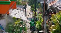
Meanwhile, across the globe in Indonesia, Gojek, the on-demand services unit of PT GoTo Gojek Tokopedia, has announced a collaboration with Google Maps aimed at enhancing the mapping experience for its users. This partnership seeks to combine Gojek’s real-time data with Google Maps’ advanced geo-technology, creating a more efficient navigation system for both consumers and driver-partners.
The collaboration is expected to optimize navigation, reduce delivery times, and improve the discoverability of micro, small, and medium enterprises (MSMEs) on the Gojek app. Catherine Hindra Sutjahyo, president of on-demand services at GoTo Group, stated, "By combining Gojek’s real-time on-the-ground data with Google Maps’ cutting-edge geo-technology, we will deliver a superior mapping experience that enhances efficiency and accessibility for millions of users across Indonesia." This initiative not only aims to improve user experience but also supports local businesses by ensuring they are more easily found by consumers.
Yael Maguire, Google VP and GM of Google Maps Platform, added that this partnership would ensure millions of people in Indonesia have access to fresh and factual information about their surroundings. As Gojek serves millions of consumers daily, the company generates critical real-time data points that provide insights into mobility patterns and road conditions. By leveraging this information, Gojek can continuously refine its navigation systems, resulting in a more seamless experience for both driver-partners and consumers.
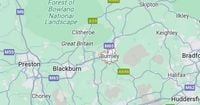
In another interesting mapping phenomenon, Google Maps has placed Great Britain in a rather peculiar location—north of Burnley, Lancashire. This has sparked curiosity and confusion among users, with many questioning why the map displays Great Britain in this specific spot. A Reddit user recently posed the question, "Why does Google Maps always show 'Great Britain' as being specifically in this spot near Burnley?" This inquiry led to a flurry of comments, with one user providing clarity on the matter.
The user, known as Waste-Session-Bubble, revealed that the pinpointed location is actually the exact center point of Great Britain. According to the Ordnance Survey, the heart of Great Britain is situated 7 kilometers northwest of Dunsop Bridge in Lancashire, near the Whitendale Hanging Stones on Brennard Farm in the Forest of Bowland. This information confirms that the mainland center of Great Britain is approximately 4 kilometers northwest of Calderstones Hospital near Clitheroe, Lancashire.
The Ordnance Survey elaborated, "Looking only at the mainland of Great Britain, the location is 4 km north west of Calderstones Hospital near Clitheroe, Lancashire." They also noted that the calculations regarding the center point were based on analogue experiments conducted by Brigadier Winterbotham, which were reported in the Geographical Journal in 1941. However, they cautioned that the precision of this reference is limited by the scale of the data used, stating, "At the 1: 625 000 scale, the precision of the reference will be to a few hundred metres."
This mapping quirk has certainly left many scratching their heads, and it has sparked a lively debate among Reddit users. One commenter, JKL246, expressed relief at finally having an answer to the puzzling question, while another user, Farsydi, shared a humorous anecdote about a friend who mistook the map for a town called Great Britain, leading to weeks of good-natured ribbing.
As these mapping anomalies unfold, they highlight the importance of accurate geographical representation in our digital age. Whether it’s the disappearance of local landmarks in Inverkeithing, the collaboration between Gojek and Google Maps to enhance navigation in Indonesia, or the curious placement of Great Britain on the map, these stories serve as reminders of the complexities and quirks of modern mapping technology.
In conclusion, the interplay of technology and geography continues to evolve, and as companies like Google strive to improve their mapping services, local communities and businesses alike stand to benefit. However, as demonstrated by these recent events, the path to accuracy is not always straightforward, and there remains much work to be done in ensuring that our maps reflect the world as it truly is.


